IMAGES TAKEN NEAR TO
Stenness, STROMNESS, KW16 3EY
Introduction
This page details the photographs taken nearby to KW16 3EY by members of the Geograph project.
The Geograph project started in 2005 with the aim of publishing, organising and preserving representative images for every square kilometre of Great Britain, Ireland and the Isle of Man.

There are currently over 7.5m images from over14,400 individuals and you can help contribute to the project by visiting https://www.geograph.org.uk
Image Map
Images are licensed for reuse under creativecommons.org/licenses/by-sa/2.0
Notes
- Clicking on the map will re-center to the selected point.
- The higher the marker number, the further away the image location is from the centre of the postcode.
Image Listing (7 Images Found)
Images are licensed for reuse under creativecommons.org/licenses/by-sa/2.0
Image
Details
Distance
1
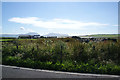
The site of Vasmire
A farm which hasn't survived. Cumminess is behind, and that is now a large farm relatively. Hoy forms the backdrop.
Image: © Bill Boaden
Taken: 30 Jul 2013
0.10 miles
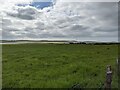
5

Field boundaries near Vasmire
From this point you can see up to the Bridge of Waithe which links the Loch of Stenness with the sea. Not all fields are in current use.
Image: © Bill Boaden
Taken: 30 Jul 2013
0.18 miles
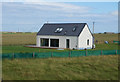
6

Sheep north of Cumminess
Looking east from the A964. The ridge of higher ground coming down from Ward Hill to the south east has all but disappeared.
Image: © Bill Boaden
Taken: 30 Jul 2013
0.20 miles
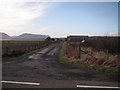
7
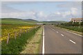
A964 towards Bridge of Waithe
Picture taken at the Mill of Eyrland.
Image: © Andrew Riley
Taken: 15 Jun 2008
0.24 miles