
IMAGES TAKEN NEAR TO
Church Road, STROMNESS, KW16 3BA
Introduction
This page details the photographs taken nearby to Church Road, KW16 3BA by members of the Geograph project.
The Geograph project started in 2005 with the aim of publishing, organising and preserving representative images for every square kilometre of Great Britain, Ireland and the Isle of Man.

There are currently over 7.5m images from over14,400 individuals and you can help contribute to the project by visiting https://www.geograph.org.uk
Image Map
Images are licensed for reuse under creativecommons.org/licenses/by-sa/2.0
Notes
- Clicking on the map will re-center to the selected point.
- The higher the marker number, the further away the image location is from the centre of the postcode.
Image Listing (335 Images Found)
Images are licensed for reuse under creativecommons.org/licenses/by-sa/2.0
Image
Details
Distance
1
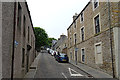
Church Road
This steep street must have been widened at some point from a vennel like Image Image] is on the right half-way up.
Image: © Anne Burgess
Taken: 9 Jun 2018
0.01 miles
2

Stromness
A calm sailing into Stromness
Image: © Douglas Nelson
Taken: 23 Apr 2003
0.01 miles
3
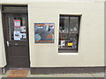
The "Harray Potter", Victoria Street, Stromness
This is the retail outlet in the main street of Stromness for an artisan pottery business located in the village of Harray in west Mainland. The pun was too good to waste
Image: © Oliver Dixon
Taken: 3 May 2015
0.01 miles
4
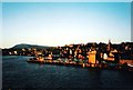
Stromness
An early morning winter sun casts a warm glow over the town of Stromness
Image: © Douglas Nelson
Taken: 31 Jan 2002
0.02 miles
5
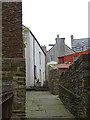
Vennel off Victoria Street
Stromness has a well-defined mediaeval street layout, except that the vennels off the east side of the main street lead to the sea, not to fields as in most owns of that age. On the west side of the main street, however, the vennels would originally have led uphill to fields, but as was common in mediaeval towns, the land off the street was gradually built over with houses.
Image: © Anne Burgess
Taken: 9 Jun 2018
0.02 miles
6
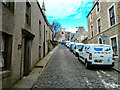
Cobbled Street in Stromness
Leads off Victoria Street to one of several churches in the town.
Image: © Andy Farrington
Taken: 16 May 2013
0.02 miles
7
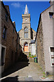
Stromness Town Hall
On my OS map it shows this building as a church. The council must have taken the building over and turned it into the Town Hall.
Image: © Ian S
Taken: 20 Jun 2018
0.02 miles
10
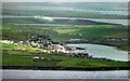
Stromness and Hamnavoe seen from Ward Hill, Hoy
The photograph was taken from near the summit cairn on Ward Hill. The stretch of water in the foreground is part of Hoy Sound. Just beyond Stromness are the two arms of the Loch of Stenness. The Loch of Harray lies beyond that in the distance.
Image: © Les Shaw
Taken: Unknown
0.02 miles