IMAGES TAKEN NEAR TO
Clay Loan, KIRKWALL, KW15 1QQ
Introduction
This page details the photographs taken nearby to Clay Loan, KW15 1QQ by members of the Geograph project.
The Geograph project started in 2005 with the aim of publishing, organising and preserving representative images for every square kilometre of Great Britain, Ireland and the Isle of Man.

There are currently over 7.5m images from over14,400 individuals and you can help contribute to the project by visiting https://www.geograph.org.uk
Image Map
Images are licensed for reuse under creativecommons.org/licenses/by-sa/2.0
Notes
- Clicking on the map will re-center to the selected point.
- The higher the marker number, the further away the image location is from the centre of the postcode.
Image Listing (338 Images Found)
Images are licensed for reuse under creativecommons.org/licenses/by-sa/2.0
Image
Details
Distance
1
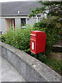
Kirkwall: postbox № KW15 113, Buttquoy Park
A small postbox, mounted on a post which is actually in the garden of the first bungalow in Buttquoy Park, emptied at 2:15pm on weekdays and 45 minutes earlier on Saturdays.
Image: © Chris Downer
Taken: 25 Jul 2011
0.07 miles
2
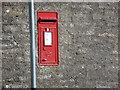
Kirkwall: postbox № KW15 3, Laverock Road
An Elizabeth II-reign postbox set into the wall as it curves into Laverock Road from Clay Loan. It is emptied finally at 2pm on weekdays and half an hour earlier on Saturdays.
Image: © Chris Downer
Taken: 27 Jul 2011
0.07 miles
3

St Olaf's Episcopal Church, Kirkwall
St Olaf's Church is situated on the north side of Bignold Park Road, the main A960 road, Kirkwall.
Image: © Bill Henderson
Taken: Unknown
0.08 miles
4
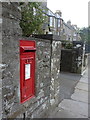
Kirkwall: postbox № KW15 4, Dundas Crescent
An Elizabeth II-reign postbox set into a wall at the boundary of two frontages in Dundas Crescent. It is emptied at 2pm on weekdays and half an hour earlier on Saturdays.
Image: © Chris Downer
Taken: 25 Jul 2011
0.10 miles
5
Orcadian Street
Victoria Road is a typical example of the slate-laid streets in the old town area of Kirkwall.
Image: © Gerald England
Taken: 15 Aug 1985
0.10 miles
6

Kirkwall Baptist Church
It has quite a vibrant congregation.
Image: © Bill Boaden
Taken: 1 Aug 2013
0.11 miles
7
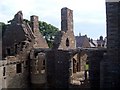
Earl's Palace, Congregational Church & Manse
Showing the top of the Earl's Palace in Kirkwall, looking up Palace Road towards the airport, with the end of the Congregational Church and the rooves of the manse and other houses.
The Earl in question was a bad lot - apparently got his kicks torturing and taxing the locals. My mother said this building exuded evil and refused to go into it, so ca' canny if you might be the same.
Image: © Kirsty Smith
Taken: 6 Aug 2003
0.11 miles
8

Kirkwall Baptist Church
Designed by T S Peace and built in 1888 in Romanesque style.
Image: © Anne Burgess
Taken: 10 Jun 2018
0.12 miles
9
Main Street
Paradoxically Main Street is not the principal street of Kirkwall. It is the short southern continuation of Victoria Street. Most of the houses are 18th century, including the West End Hotel with the blue window embrasures, which was built in 1824 for William Richan of Rapness.
Image: © Anne Burgess
Taken: 10 Jun 2018
0.12 miles
10

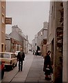
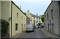
Street down from County Show Ground, Kirkwall
Can't remember name of the street, eh....up the road/hill from the West End Hotel ;-)
Image: © Wayne Easton
Taken: 14 Aug 2010
0.12 miles