IMAGES TAKEN NEAR TO
Castletown Road, THURSO, KW14 8HL
Introduction
This page details the photographs taken nearby to Castletown Road, KW14 8HL by members of the Geograph project.
The Geograph project started in 2005 with the aim of publishing, organising and preserving representative images for every square kilometre of Great Britain, Ireland and the Isle of Man.

There are currently over 7.5m images from over14,400 individuals and you can help contribute to the project by visiting https://www.geograph.org.uk
Image Map (Loading...)


Getting Data...Please wait
Leaflet Map data © OpenStreetMap
Images are licensed for reuse under creativecommons.org/licenses/by-sa/2.0
Notes
- Clicking on the map will re-center to the selected point.
- The higher the marker number, the further away the image location is from the centre of the postcode.
Image Listing (50 Images Found)
Images are licensed for reuse under creativecommons.org/licenses/by-sa/2.0
Image
Details
Distance


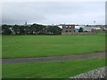
3

Co-operative food store on Mountpleasant Road
Image: © JThomas
Taken: 14 Aug 2016
0.10 miles
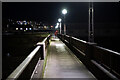
5
Footbridge across River Thurso
This well-used footbridge links Thurso East with Thurso.
Image: © Bob Jones
Taken: 9 May 2009
0.12 miles
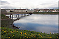
6
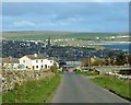
Thurso from the hill at Mountpleasant
Looking down Mountpleasant into Thurso. Thurso Bay with Scrabster is on the right of this picture.
Image: © Dorcas Sinclair
Taken: 11 May 2005
0.13 miles
7
The Ellan footbridge, Thurso
Crossing the Thurso River.
Image: © John Lucas
Taken: 9 Dec 2021
0.13 miles
8
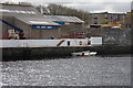
Sea Cadet base, Thurso
The Sea Cadets have a base on the east bank of the River Thurso. A short section of quay allows small boats to be moored alongside.
Image: © Bob Jones
Taken: 9 May 2009
0.13 miles
9
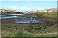
Thurso Harbour and river mouth at low tide
Image: © Alan Reid
Taken: 7 May 2021
0.14 miles
10
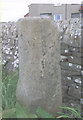
Old Milestone by the A836, Thurso East, Thurso parish
Stone post by the A836, in parish of Thurso (Caithness District), Thurso East, by wall dividing the A836 from Harald Drive.
Inscription reads:-
: Thurso / 1 : : Wick / 20 :
Surveyed
Milestone Society National ID: HI_THWK01N
Image: © Milestone Society
Taken: Unknown
0.14 miles