IMAGES TAKEN NEAR TO
Orchid Close, CHESSINGTON, KT9 2SH
Introduction
This page details the photographs taken nearby to Orchid Close, KT9 2SH by members of the Geograph project.
The Geograph project started in 2005 with the aim of publishing, organising and preserving representative images for every square kilometre of Great Britain, Ireland and the Isle of Man.

There are currently over 7.5m images from over14,400 individuals and you can help contribute to the project by visiting https://www.geograph.org.uk
Image Map
Images are licensed for reuse under creativecommons.org/licenses/by-sa/2.0
Notes
- Clicking on the map will re-center to the selected point.
- The higher the marker number, the further away the image location is from the centre of the postcode.
Image Listing (18 Images Found)
Images are licensed for reuse under creativecommons.org/licenses/by-sa/2.0
Image
Details
Distance
2
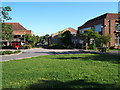
Close off Merritt Gardens, Chessington
This area was built in 1998/99 on an area that was mostly open green fields but as it was the grounds of a public building it was not strictly greenbelt, rather 'brownfield' and therefore planning permission was available to build on it.
Image: © Hugh Venables
Taken: 6 Nov 2010
0.11 miles
3
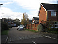
Path into a housing estate, Chessington
A path into a housing estate in Chessington, on the outer fringe of south west London.
Image: © Malc McDonald
Taken: 25 Feb 2023
0.12 miles
4
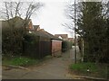
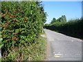
Path to Chessington
This footpath comes from Claygate and passes through The Grapsome, then under the Esher By-pass (A3) before reaching the outskirts of Chessington ahead.
Image: © Marathon
Taken: 25 Sep 2013
0.12 miles
5
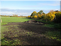
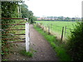
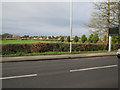
Barwell Court Farm field
This farm used to be a dairy farm but the loss of land to the A3 and the increase in demand for horse riding means it is now fully turned over to horses and doesn't produce any food. The houses to the right were built in 1998/9 on the grounds of some public buildings, which were designated at 'brownfield', despite largely being open green space.
Image: © Hugh Venables
Taken: 6 Nov 2010
0.12 miles
6
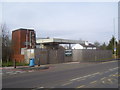
Disused petrol station on the Leatherhead Road
Image: © peter clayton
Taken: 31 Jan 2010
0.15 miles
7
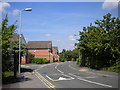
Merritt Gardens, Chessington (2)
The main distributor road through a relatively recent housing development west of Leatherhead Road.
Image: © Richard Vince
Taken: 16 May 2014
0.15 miles
8
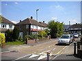
Burton Close, Chessington
A short residential cul de sac off Leatherhead Road.
Image: © Richard Vince
Taken: 16 May 2014
0.16 miles
9
Barwell Lane at Chessington
Barwell Lane leads from Chessington South station to the foot of Winey Hill and on to the adjoining countryside. This view looks back towards Leatherwood Road and the station.
Image: © Marathon
Taken: 4 Sep 2013
0.16 miles
10
Recreation ground off Leatherhead Road
Image: © Hugh Venables
Taken: 30 Dec 2015
0.17 miles