IMAGES TAKEN NEAR TO
Field Close, CHESSINGTON, KT9 2QD
Introduction
This page details the photographs taken nearby to Field Close, KT9 2QD by members of the Geograph project.
The Geograph project started in 2005 with the aim of publishing, organising and preserving representative images for every square kilometre of Great Britain, Ireland and the Isle of Man.

There are currently over 7.5m images from over14,400 individuals and you can help contribute to the project by visiting https://www.geograph.org.uk
Image Map
Images are licensed for reuse under creativecommons.org/licenses/by-sa/2.0
Notes
- Clicking on the map will re-center to the selected point.
- The higher the marker number, the further away the image location is from the centre of the postcode.
Image Listing (8 Images Found)
Images are licensed for reuse under creativecommons.org/licenses/by-sa/2.0
Image
Details
Distance
1
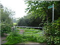
Bridleway leading off Mansfield Road
This bridleway leaves Mansfield Road to run southwards along the edge of a field, parallel to the Esher By-pass. The bridleway tends to get churned up by horses and as there is no way to avoid the resultant mud in places, an unofficial footpath has been created in the field next to the bridleway.
Image: © Marathon
Taken: 25 Sep 2013
0.03 miles
2
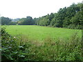
Field near Mansfield Road, Chessington
A bridleway leaves Mansfield Road to run southwards along the edge of this field, parallel to the Esher By-pass. The bridleway tends to get churned up by horses and as there is no way to avoid the resultant mud in places, an unofficial footpath has been created in the field next to the bridleway. This is the view from the bridleway looking in the direction of the Esher By-pass.
Image: © Marathon
Taken: 25 Sep 2013
0.09 miles
5
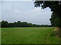
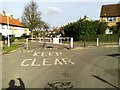
Field on the edge of Chessington
A bridleway leaves Mansfield Road to run southwards along the edge of this field, parallel to the Esher By-pass. The bridleway tends to get churned up by horses and as there is no way to avoid the resultant mud in places, an unofficial footpath has been created in the field next to the bridleway. This view looks back along the unofficial path with the bridleway in the trees to the right. The Esher By-pass is beyond the trees to the left.
Image: © Marathon
Taken: 25 Sep 2013
0.16 miles
6
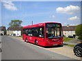
Bus on Ripon Gardens, Hook
One of London United's short wheelbase Alexander Dennis Enviro 200s enjoys its half hour layover on Ripon Gardens in Mansfield Park estate, Hook, before operating a K4 to Kingston Hospital.
Image: © Richard Vince
Taken: 16 May 2014
0.19 miles
7
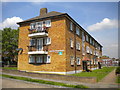
Flats on Ripon Gardens, Hook
One of four blocks of low rise flats on the north side of Ripon Gardens in Mansfield Park estate, Hook.
Image: © Richard Vince
Taken: 16 May 2014
0.24 miles
8
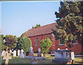
St Paul's Church, Hook
A traiditional church in the Diocese of Southwark only a mile away from Guildford Diocese
Image: © Linda Craven
Taken: Unknown
0.24 miles