IMAGES TAKEN NEAR TO
Leatherhead Road, CHESSINGTON, KT9 2NG
Introduction
This page details the photographs taken nearby to Leatherhead Road, KT9 2NG by members of the Geograph project.
The Geograph project started in 2005 with the aim of publishing, organising and preserving representative images for every square kilometre of Great Britain, Ireland and the Isle of Man.

There are currently over 7.5m images from over14,400 individuals and you can help contribute to the project by visiting https://www.geograph.org.uk
Image Map
Images are licensed for reuse under creativecommons.org/licenses/by-sa/2.0
Notes
- Clicking on the map will re-center to the selected point.
- The higher the marker number, the further away the image location is from the centre of the postcode.
Image Listing (20 Images Found)
Images are licensed for reuse under creativecommons.org/licenses/by-sa/2.0
Image
Details
Distance
1
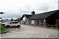
Chessington Garden Centre
Located beside the A243, south of Chessington. The garden centre is a little larger than I had anticipated, with a huge restaurant. The meal was excellent and I anticipate a return visit.
Image: © Peter Trimming
Taken: 4 Mar 2020
0.04 miles
3
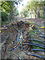
Cable laying, Chessington
This appears to be a splicing point, where cables that have been pulled through plastic pipes are joined together.
Image: © Robin Webster
Taken: 3 Sep 2012
0.12 miles
4
Footpath with cable laying, Chessington
The cables appeared to be for telecommunications - see Image
Image: © Robin Webster
Taken: 3 Sep 2012
0.13 miles
5
Access road, Chessington World of Adventures
An access road at Chessington World of Adventures, a visitor attraction on the fringe of south west London. The attraction was previously known as Chessington Zoo.
Image: © Malc McDonald
Taken: 25 Feb 2023
0.14 miles
6
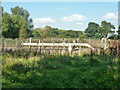
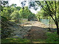
Pipeline compound, Chessington
Presumably gas, but a GPSS oil products pipeline marker is also on the nearby road verge.
Image: © Robin Webster
Taken: 3 Sep 2012
0.17 miles
7
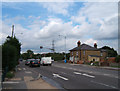
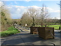
Crossroads at Malden Rushett
Junction of A243 and B280 looking north in the direction of Chessington World of Adventures.
Image: © Roger Miller
Taken: 5 Aug 2005
0.17 miles
8
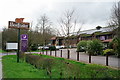
Chessington Premier Inn
The Beefeater is just out of picture, to the right. Both are conveniently sited for the Chessington World of Adventures complex.
Image: © Peter Trimming
Taken: 4 Mar 2020
0.20 miles
9
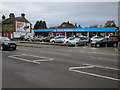
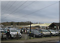
Evans Halshaw car store
Car showroom in Malden Rushett, a long time ago it was a TVR showroom.
Image: © Hugh Venables
Taken: 30 Dec 2015
0.20 miles
10
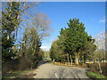
Public footpath and access road, Chessington World of Adventures
A public footpath and access road at Chessington World of Adventures, on the fringe of south west London. The access road leads to and from car parks for visitors to the site. The footpath, which runs around the perimeter of Chessington World of Adventures, is a public right of way.
This image was taken in a February afternoon. Trees were bare for the winter season.
Image: © Malc McDonald
Taken: 25 Feb 2023
0.21 miles