IMAGES TAKEN NEAR TO
Garrison Lane, CHESSINGTON, KT9 2JR
Introduction
This page details the photographs taken nearby to Garrison Lane, KT9 2JR by members of the Geograph project.
The Geograph project started in 2005 with the aim of publishing, organising and preserving representative images for every square kilometre of Great Britain, Ireland and the Isle of Man.

There are currently over 7.5m images from over14,400 individuals and you can help contribute to the project by visiting https://www.geograph.org.uk
Image Map
Images are licensed for reuse under creativecommons.org/licenses/by-sa/2.0
Notes
- Clicking on the map will re-center to the selected point.
- The higher the marker number, the further away the image location is from the centre of the postcode.
Image Listing (59 Images Found)
Images are licensed for reuse under creativecommons.org/licenses/by-sa/2.0
Image
Details
Distance
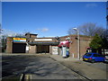
2
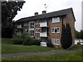
Chessington - Block of Flats near Garrison Lane
Image: © James Emmans
Taken: 18 Aug 2016
0.01 miles
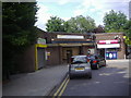
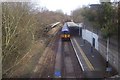
6
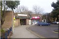
Entrance to Chessington South station
The station was opened in 1939 according to 'Surbiton Past' authored by Richard Statham (1996, Phillimore & Co Ltd)
Image: © peter clayton
Taken: 31 Jan 2010
0.02 miles
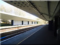
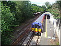
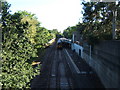
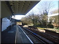
9
Chessington South Station from Garrison Lane bridge
The railway line to Chessington South was completed in 1939
Image: © peter clayton
Taken: 31 Jan 2010
0.04 miles