IMAGES TAKEN NEAR TO
Hemsby Road, CHESSINGTON, KT9 2DZ
Introduction
This page details the photographs taken nearby to Hemsby Road, KT9 2DZ by members of the Geograph project.
The Geograph project started in 2005 with the aim of publishing, organising and preserving representative images for every square kilometre of Great Britain, Ireland and the Isle of Man.

There are currently over 7.5m images from over14,400 individuals and you can help contribute to the project by visiting https://www.geograph.org.uk
Image Map
Images are licensed for reuse under creativecommons.org/licenses/by-sa/2.0
Notes
- Clicking on the map will re-center to the selected point.
- The higher the marker number, the further away the image location is from the centre of the postcode.
Image Listing (66 Images Found)
Images are licensed for reuse under creativecommons.org/licenses/by-sa/2.0
Image
Details
Distance
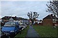

9
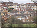
Chessington from the South
Suburban rooftops rising above the green belt at the south-western edge of the Greater London built up area.
Image: © Colin Smith
Taken: 9 Mar 2012
0.11 miles
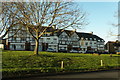
10
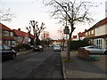
Church Rise, Chessington
These sort of houses circle most of London from around 6 miles to the edge.
Image: © David Howard
Taken: 5 Nov 2012
0.11 miles