IMAGES TAKEN NEAR TO
Rutland Close, CHESSINGTON, KT9 2AW
Introduction
This page details the photographs taken nearby to Rutland Close, KT9 2AW by members of the Geograph project.
The Geograph project started in 2005 with the aim of publishing, organising and preserving representative images for every square kilometre of Great Britain, Ireland and the Isle of Man.

There are currently over 7.5m images from over14,400 individuals and you can help contribute to the project by visiting https://www.geograph.org.uk
Image Map
Images are licensed for reuse under creativecommons.org/licenses/by-sa/2.0
Notes
- Clicking on the map will re-center to the selected point.
- The higher the marker number, the further away the image location is from the centre of the postcode.
Image Listing (62 Images Found)
Images are licensed for reuse under creativecommons.org/licenses/by-sa/2.0
Image
Details
Distance
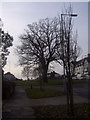
2
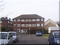
Maisonettes in May Close
There are several similar buildings in May Close.
Image: © peter clayton
Taken: 31 Jan 2010
0.05 miles
5
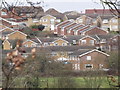
Chessington from the South
Suburban rooftops rising above the green belt at the south-western edge of the Greater London built up area.
Image: © Colin Smith
Taken: 9 Mar 2012
0.10 miles
6
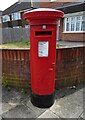
George VI postbox on Moor Lane, Chessington
Postbox No. KT9 305.
Image: © JThomas
Taken: 25 Jul 2022
0.11 miles
8
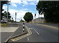
Moor Lane Junction with Gilders Road
Bus route on residential roads.
Image: © James Emmans
Taken: 18 Aug 2016
0.14 miles
10
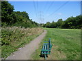
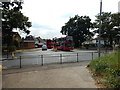
Pylons through Bonesgate Open Space
Bonesgate Open Space lies to the north of Castle Hill. The Bonesgate Stream rises at Malden Rushett in the far south of the Royal Borough of Kingston upon Thames. In the early years of the 20th century the Bonesgate Stream was known as ‘The Rythe’ a name which is today attached to a totally different stream to the west of the Borough. The origin of the name ‘Bonesgate’ stems from the Old English Bone or Bonne which would have been a proper name, and gate meaning a gap in a wall, hence a gap in a wall belonging to Bonne. The name has nothing to do with plague pits.
In this photograph, the Bonesgate Stream is within the trees on the left. Moor Lane is just ahead and the long distance path the Thames Down Link passes through Bonesgate Open Space. The Thames Down Link is a 15 mile official walking route linking the Thames Path at Kingston upon Thames and the North Downs Way at Box Hill & Westhumble station.
Image: © Marathon
Taken: 4 Sep 2013
0.14 miles