IMAGES TAKEN NEAR TO
North Parade, CHESSINGTON, KT9 1QL
Introduction
This page details the photographs taken nearby to North Parade, KT9 1QL by members of the Geograph project.
The Geograph project started in 2005 with the aim of publishing, organising and preserving representative images for every square kilometre of Great Britain, Ireland and the Isle of Man.

There are currently over 7.5m images from over14,400 individuals and you can help contribute to the project by visiting https://www.geograph.org.uk
Image Map
Images are licensed for reuse under creativecommons.org/licenses/by-sa/2.0
Notes
- Clicking on the map will re-center to the selected point.
- The higher the marker number, the further away the image location is from the centre of the postcode.
Image Listing (53 Images Found)
Images are licensed for reuse under creativecommons.org/licenses/by-sa/2.0
Image
Details
Distance
6
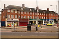
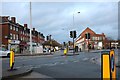
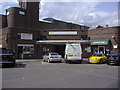
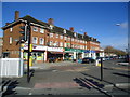
Bridge Road, Chessington
At the junction of Marston Road
Image: © David Howard
Taken: 1 Dec 2018
0.03 miles
8
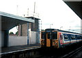
Train calling at Chessington North station
Chessington North is quite convenient to park a car for free and hop in a train to London Waterloo with an "all zones" Travelcard.
Image: © Patrick GUEULLE
Taken: Unknown
0.04 miles
10
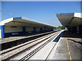
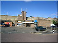
Chessington North station
Construction of the Chessington line from Motspur Park began in 1936 and opened as far as Chessington South in 1939. Intermediate stations were opened at Malden Manor, Tolworth and Chessington North. Although there was a little house building near Chessington North before the Second World War, the majority of building stimulated by the line came after 1945. This was largely to the north and west of the line and today the area to the south and east along the valley of the Hogsmill River and Bonesgate Stream remains relatively undeveloped.
Powers had been obtained to continue the line to Leatherhead but work halted following financial problems and the onset of war. Following the war most of the undulating wood and common land south of Chessington became part of the Green Belt and the proposed extension was abandoned.
All the stations are in the rather stark 1930s style seen here at Chessington North. Concrete was much used for all four stations on the line and they were of the same basic design derived from Wimbledon Chase station – see http://www.geograph.org.uk/photo/3094055 An attempt was made to integrate the street buildings of the station with the platform structures and so emulate what London Transport was doing in the 1930s. The Southern Railway’s attempts were far less successful and the smooth lines of the stations were striking when the materials remained unweathered. However, the once very modern-looking stations now look the worse for wear.
This is the view from the down platform looking up the line towards London. The day was as hot as it looks.
Image: © Marathon
Taken: 4 Sep 2013
0.05 miles