IMAGES TAKEN NEAR TO
Selwood Road, CHESSINGTON, KT9 1PT
Introduction
This page details the photographs taken nearby to Selwood Road, KT9 1PT by members of the Geograph project.
The Geograph project started in 2005 with the aim of publishing, organising and preserving representative images for every square kilometre of Great Britain, Ireland and the Isle of Man.

There are currently over 7.5m images from over14,400 individuals and you can help contribute to the project by visiting https://www.geograph.org.uk
Image Map
Images are licensed for reuse under creativecommons.org/licenses/by-sa/2.0
Notes
- Clicking on the map will re-center to the selected point.
- The higher the marker number, the further away the image location is from the centre of the postcode.
Image Listing (32 Images Found)
Images are licensed for reuse under creativecommons.org/licenses/by-sa/2.0
Image
Details
Distance
1
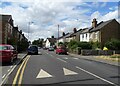
Clayton Road, Chessington
Towards Claygate.
Image: © JThomas
Taken: 25 Jul 2022
0.04 miles
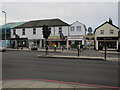
2
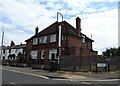
The Cricketers on Clayton Road, Chessington
Image: © JThomas
Taken: 25 Jul 2022
0.05 miles
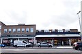
3
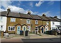
Victorian cottages on Clayton Road, Chessington
Image: © JThomas
Taken: 25 Jul 2022
0.07 miles
4
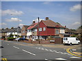
Houses on Clayton Road, Hook
On the corner of Bramham Gardens.
Image: © Richard Vince
Taken: 16 May 2014
0.09 miles
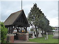
5
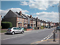
Hook village
Some older houses in Hook village near to the centre of grid square.
Image: © Dennis Turner
Taken: 21 Aug 2005
0.15 miles