IMAGES TAKEN NEAR TO
Clayton Road, CHESSINGTON, KT9 1NN
Introduction
This page details the photographs taken nearby to Clayton Road, KT9 1NN by members of the Geograph project.
The Geograph project started in 2005 with the aim of publishing, organising and preserving representative images for every square kilometre of Great Britain, Ireland and the Isle of Man.

There are currently over 7.5m images from over14,400 individuals and you can help contribute to the project by visiting https://www.geograph.org.uk
Image Map
Images are licensed for reuse under creativecommons.org/licenses/by-sa/2.0
Notes
- Clicking on the map will re-center to the selected point.
- The higher the marker number, the further away the image location is from the centre of the postcode.
Image Listing (9 Images Found)
Images are licensed for reuse under creativecommons.org/licenses/by-sa/2.0
Image
Details
Distance
1
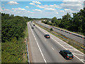
A3 near Hook
The Portsmouth road heading towards the Hook interchange and London.
Image: © Dennis Turner
Taken: 21 Aug 2005
0.11 miles
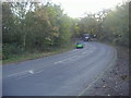
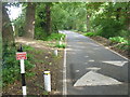
2
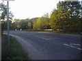
Clayton Road, Claygate
Just before the junction with Woodstock Lane South.
Image: © David Howard
Taken: 25 Oct 2009
0.13 miles
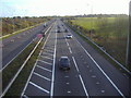
3
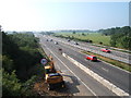
A3(T) from bridge near Hook
Taken from approx TQ 171 647 looking south.
Image: © Roger Miller
Taken: 4 Sep 2005
0.18 miles
4
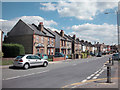
Hook village
Some older houses in Hook village near to the centre of grid square.
Image: © Dennis Turner
Taken: 21 Aug 2005
0.19 miles
5
Woodstock Lane, Claygate
Just across the London border into Surrey.
Image: © David Howard
Taken: 25 Oct 2009
0.19 miles
7
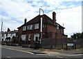
The Cricketers on Clayton Road, Chessington
Image: © JThomas
Taken: 25 Jul 2022
0.22 miles
8
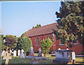
St Paul's Church, Hook
A traiditional church in the Diocese of Southwark only a mile away from Guildford Diocese
Image: © Linda Craven
Taken: Unknown
0.23 miles
9
The approach to Surbiton Golf Club
Surbiton Golf Course is actually situated between Long Ditton and Claygate, to the south of the Kingston By-Pass. This is looking back along the drive which leads to the clubhouse in the direction of Woodstock Lane South. A footpath also follows this lane. Here the golf course is to the left and a field with horses is to the right.
Image: © Marathon
Taken: 25 Sep 2013
0.24 miles