IMAGES TAKEN NEAR TO
Mount Road, CHESSINGTON, KT9 1JG
Introduction
This page details the photographs taken nearby to Mount Road, KT9 1JG by members of the Geograph project.
The Geograph project started in 2005 with the aim of publishing, organising and preserving representative images for every square kilometre of Great Britain, Ireland and the Isle of Man.

There are currently over 7.5m images from over14,400 individuals and you can help contribute to the project by visiting https://www.geograph.org.uk
Image Map
Images are licensed for reuse under creativecommons.org/licenses/by-sa/2.0
Notes
- Clicking on the map will re-center to the selected point.
- The higher the marker number, the further away the image location is from the centre of the postcode.
Image Listing (55 Images Found)
Images are licensed for reuse under creativecommons.org/licenses/by-sa/2.0
Image
Details
Distance
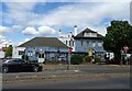
3

Chessington Oak public house
For many years this alehouse was called 'The Blackamoor's Head' and had separate lounge and public bars.
Image: © peter clayton
Taken: 31 Jan 2010
0.08 miles

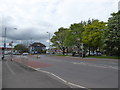
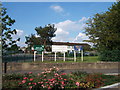
7
Chessington
Looking along Moor Lane, from the junction with Church Lane.
Image: © Peter Trimming
Taken: 4 Mar 2020
0.08 miles
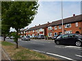
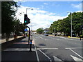
8
Moor Lane, Chessington
Moor Lane is a dual-carriageway in Chessington, in the outer suburbs of south west London. Signs indicate that the speed limit changes to 30 miles per hour here.
Image: © Malc McDonald
Taken: 25 Feb 2023
0.09 miles