IMAGES TAKEN NEAR TO
Applegrove, CHESSINGTON, KT9 1BE
Introduction
This page details the photographs taken nearby to Applegrove, KT9 1BE by members of the Geograph project.
The Geograph project started in 2005 with the aim of publishing, organising and preserving representative images for every square kilometre of Great Britain, Ireland and the Isle of Man.

There are currently over 7.5m images from over14,400 individuals and you can help contribute to the project by visiting https://www.geograph.org.uk
Image Map
Images are licensed for reuse under creativecommons.org/licenses/by-sa/2.0
Notes
- Clicking on the map will re-center to the selected point.
- The higher the marker number, the further away the image location is from the centre of the postcode.
Image Listing (29 Images Found)
Images are licensed for reuse under creativecommons.org/licenses/by-sa/2.0
Image
Details
Distance
2
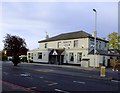
The 'North Star', Hook Road, during lockdown, May 2020
Photo taken at about 19.40 on a Monday evening.
Image: © Stefan Czapski
Taken: 18 May 2020
0.07 miles
5
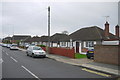
Bungalows in Orchard Gardens
Many of these bungalows have been extended at the sides or rear.These houses are close to the junction with Rose Mary Gardens.
Image: © Nigel Mykura
Taken: 3 Dec 2015
0.11 miles
6

Parish Hall, Hook
By A243, Hook Road.
Image: © Hugh Venables
Taken: 30 Dec 2015
0.13 miles
10
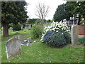
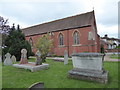
St Paul, Hook: the churchyard as spring beckons
Image: © Basher Eyre
Taken: 24 Apr 2019
0.14 miles