IMAGES TAKEN NEAR TO
Summer Road, EAST MOLESEY, KT8 9LR
Introduction
This page details the photographs taken nearby to Summer Road, KT8 9LR by members of the Geograph project.
The Geograph project started in 2005 with the aim of publishing, organising and preserving representative images for every square kilometre of Great Britain, Ireland and the Isle of Man.

There are currently over 7.5m images from over14,400 individuals and you can help contribute to the project by visiting https://www.geograph.org.uk
Image Map
Images are licensed for reuse under creativecommons.org/licenses/by-sa/2.0
Notes
- Clicking on the map will re-center to the selected point.
- The higher the marker number, the further away the image location is from the centre of the postcode.
Image Listing (128 Images Found)
Images are licensed for reuse under creativecommons.org/licenses/by-sa/2.0
Image
Details
Distance
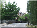
1
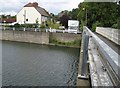
River Ember: Summer Road footbridge
It's extraordinary what old Ordnance Survey maps can tell us about the history of a location. Here we have the River Ember flowing in the concrete flood relief channel built in the 1970s.
But go back to 1872 and the Ember would have looked much narrower, flowing and meandering like an ordinary river. However a footbridge crossing of the river already existed here at that time, linking East Molesey with Thames Ditton, and the track to and from the crossing followed the present-day alignment of Summer Road, even though there were no houses along it at that time.
By 1898 a ford and a footbridge are shown on the mapping here, while most of the houses on the south side of Summer Road had been built.
By 1920 most of the houses on the north side of Summer Road had been built along with Summer Gardens on the south side. Access across the river was still via the ford and footbridge. But by 1938 the ford is no longer marked on the map and the alignment of Molember Road and its first few houses are shown. Whether or not an actual road bridge was ever built across here I do not know.
Image: © Nigel Cox
Taken: 13 Aug 2008
0.01 miles
2
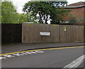
Molember Road electricity substation, East Molesey
The electricity substation is in a wooden enclosure. As its name suggests,
Molember Road is located between two rivers, the Mole and the Ember.
Image: © Jaggery
Taken: 29 Apr 2017
0.02 miles
3
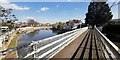
Footbridge across the River Ember
The River Ember is a short section of the River Mole running through East Molesey.
After the 1930's the River Mole distributary was re-routed into the River Ember.
River Ember : https://en.wikipedia.org/wiki/River_Ember
Distributary : https://en.wikipedia.org/wiki/Distributary
More details relating to the bridge and are here : https://www.geograph.org.uk/photo/939042
This photo was taken using the wide angle lens on the Huawei Mate20 X mobile.
Image: © James Emmans
Taken: 24 Mar 2019
0.03 miles
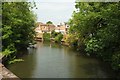
4
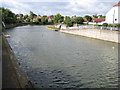
River Ember (2)
The broad sweep of the River Ember is viewed here looking upstream from the Summer Road footbridge. The river clips across the north-western corner of this grid square, with Thames Ditton on the left and East Molesey on the right.
Image: © Nigel Cox
Taken: 13 Aug 2008
0.03 miles
5
Esher Road, East Molesey
Esher Road (B3379), showing the bridge carrying the road over the River Mole at East Molesey.
Image: © Malc McDonald
Taken: 20 Jun 2010
0.03 miles
6
River Mole, East Molesey
From the bridge visible in Image], looking downstream. The house are on Molember Road, a cul-de-sac named after the fact that it runs along a narrow near-island between the Rivers Mole and Ember.
Image: © Derek Harper
Taken: 29 May 2016
0.03 miles
7
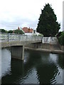
Bridge over the River Ember
Pedestrian bridge across the River Ember at East Molesey, linking two sections of Summer Road.
Image: © Malc McDonald
Taken: 20 Jun 2010
0.03 miles
8
East Molesey: Esher Road bridge over the River Mole
The steel girder and latticework bridge, which is in need of some paint, carries the B3379 Esher Road over the River Mole. On the right is a newer footbridge. For an earlier view of the bridge from the other end and before the footbridge was built see http://www.moleseyhistory.co.uk/pictures/pages/A07_0074.htm
Image: © Nigel Cox
Taken: 13 Aug 2008
0.03 miles
9
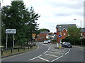
Esher Road, East Molesey
Esher Road (B3379), approaching the junction with Walton Road and Bridge Road at East Molesey.
Image: © Malc McDonald
Taken: 20 Jun 2010
0.03 miles
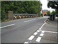
10
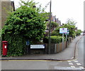
King George VI pillarbox, Summer Road, East Molesey
Near the corner of Esher Road.
Image: © Jaggery
Taken: 29 Apr 2017
0.03 miles