IMAGES TAKEN NEAR TO
Hampton Court Crescent, Graburn Way, EAST MOLESEY, KT8 9BA
Introduction
This page details the photographs taken nearby to Hampton Court Crescent, Graburn Way, KT8 9BA by members of the Geograph project.
The Geograph project started in 2005 with the aim of publishing, organising and preserving representative images for every square kilometre of Great Britain, Ireland and the Isle of Man.

There are currently over 7.5m images from over14,400 individuals and you can help contribute to the project by visiting https://www.geograph.org.uk
Image Map
Images are licensed for reuse under creativecommons.org/licenses/by-sa/2.0
Notes
- Clicking on the map will re-center to the selected point.
- The higher the marker number, the further away the image location is from the centre of the postcode.
Image Listing (142 Images Found)
Images are licensed for reuse under creativecommons.org/licenses/by-sa/2.0
Image
Details
Distance
1
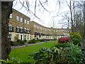
Houses in Hampton Court Crescent
These rather exclusive houses in Hampton Court Crescent have their own private garden at the back overlooking the River Thames and Ash Island. This is the view from the towpath.
Image: © Marathon
Taken: 2 Apr 2014
0.03 miles
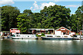
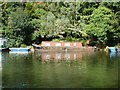
2
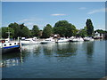
Boats near Molesey Lock
Molesey Lock is situated the River Thames near Hampton Court Palace to the west of London.
The lock was built by the City of London Corporation in 1815 and is the second longest on the river at over 268 ft (81.78 m).
http://en.wikipedia.org/wiki/Molesey_Lock
Image: © Paul Gillett
Taken: 24 Jun 2006
0.04 miles
5
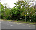
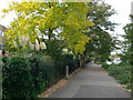
Hurst Road bus stop, East Molesey
On the north side of the A3050 Hurst Road.
Image: © Jaggery
Taken: 29 Apr 2017
0.05 miles
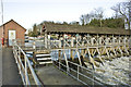
6
Premises on Ash Island
The banner on the left proclaims 'Slipway for hire', but looking at the small print, this seems to mean use of slipway (for a fee), for various boating maintenance purposes, which may be optionally supplied (for a fee).
Image: © Robin Webster
Taken: 26 Aug 2012
0.06 miles
7
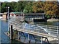
Weir at Molesey Lock
main fixed weir in the middle, fixed overspill area in the foreground and sluice gates in the background - the latter can be moved to help control the flow of the river.
Image: © Hugh Venables
Taken: 3 Sep 2006
0.06 miles
9
Scruffy narrow boat moored on River Thames
On Ash Island, it might be called 'Marie Elizabeth'.
Image: © Robin Webster
Taken: 26 Aug 2012
0.06 miles
10
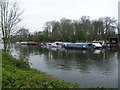
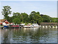
Looking across to Ash Island
This is the view from the Barge Walk, which is the Thames towpath upriver of Hampton Court Bridge. Ash Island is largely wooded but is surrounded for much of the way round by moored boats, except at the north where there is a weir.
Image: © Marathon
Taken: 2 Apr 2014
0.07 miles