IMAGES TAKEN NEAR TO
Island Farm Road, WEST MOLESEY, KT8 2LH
Introduction
This page details the photographs taken nearby to Island Farm Road, KT8 2LH by members of the Geograph project.
The Geograph project started in 2005 with the aim of publishing, organising and preserving representative images for every square kilometre of Great Britain, Ireland and the Isle of Man.

There are currently over 7.5m images from over14,400 individuals and you can help contribute to the project by visiting https://www.geograph.org.uk
Image Map
Images are licensed for reuse under creativecommons.org/licenses/by-sa/2.0
Notes
- Clicking on the map will re-center to the selected point.
- The higher the marker number, the further away the image location is from the centre of the postcode.
Image Listing (49 Images Found)
Images are licensed for reuse under creativecommons.org/licenses/by-sa/2.0
Image
Details
Distance
4
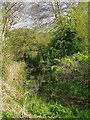
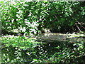
The Dead River, West Molesey
Looking at the water in this narrow channel I saw no evidence of flow, in either direction - so I assume that's why the map labels it the Dead River. It can certainly be described as a tributary of the Mole, as it joins that river a couple of hundred yards further east; but it may also be a distributary of the Mole - tracing its origins 'upstream' is not simple.
Just out of shot to the left are the back-gardens of houses in Island Farm Road, and allotments. The public open space to the right of the 'river' is Molesey Heath - a local nature reserve.
Image: © Stefan Czapski
Taken: 30 Apr 2012
0.06 miles
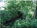
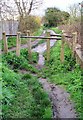
7
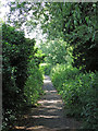
Footpath by the Dead River east of Approach Road
Image: © Mike Quinn
Taken: 6 Jun 2018
0.07 miles
8

Cuckoo flower, growing by the Dead River
Growing in a damp situation close to the river.
There are other common names for Cardamine pratense, but I prefer 'cuckoo flower' - as the plant comes into bloom at about the time the cuckoo is (or should I say was?) first heard. On the day I took the photo I heard no cuckoos - but I'd hardly expect to, not at Molesey. Bird migration was under way, though - there were swallows feeding over the local reservoir.
Image: © Stefan Czapski
Taken: 5 Apr 2014
0.07 miles
9
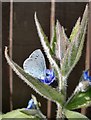
Holly Blue butterfly on Green Alkanet, West Molesey
April 30th was probably the sunniest day of April, 2012 - and frankly, there wasn't much competition, the month was the wettest April on record. I had seen very few butterflies in previous weeks (in March rather than April) so I was pleased to see my first holly blue and orange-tips of the season on the wing - by the so-called Dead River (at the end of Approach Road).
In my experience the Holly Blue, Celastrina argiolus, is a species typical of suburban streets and gardens - but not often as approachable as this one. The only other blue butterfly likely to be seen in such places is the Common Blue, Polyomattus icarus - but that has a more complex underwing pattern, with orange, black and white markings on a ground which shades from blue-grey to buff.
Image: © Stefan Czapski
Taken: 30 Apr 2012
0.08 miles
10
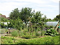
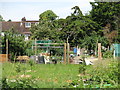
Stile by Ray Road Allotments on footpath alongside River Mole
Image: © Walter Koscielniak
Taken: 5 Apr 2008
0.09 miles