IMAGES TAKEN NEAR TO
Brockenhurst, WEST MOLESEY, KT8 2HJ
Introduction
This page details the photographs taken nearby to Brockenhurst, KT8 2HJ by members of the Geograph project.
The Geograph project started in 2005 with the aim of publishing, organising and preserving representative images for every square kilometre of Great Britain, Ireland and the Isle of Man.

There are currently over 7.5m images from over14,400 individuals and you can help contribute to the project by visiting https://www.geograph.org.uk
Image Map
Images are licensed for reuse under creativecommons.org/licenses/by-sa/2.0
Notes
- Clicking on the map will re-center to the selected point.
- The higher the marker number, the further away the image location is from the centre of the postcode.
Image Listing (25 Images Found)
Images are licensed for reuse under creativecommons.org/licenses/by-sa/2.0
Image
Details
Distance
1
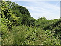
Footpath and the Dead River south Pool Road
See also Image
Image: © Mike Quinn
Taken: 6 Jun 2018
0.01 miles
4
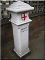
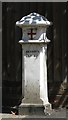
West Molesey: Molesey Road Coal & Wine Tax Post
These posts were a means of marking the point at which duty became payable on coal and wine being transported into the City of London. The coat of arms depicted is that of the City of London, with the shield bearing the Cross of St George and the Sword of St Paul, painted red on a white background. The text
4&25VICT
CAP 42
refers to the Act of Parliament under which statute they were erected - in this instance the London Coal and Wine Duties Continuance Act of 1861.
For a view of the post in its street context please see Image For a very comprehensive and interesting history of these posts please refer to Elmbridge Borough Council's dedicated website page here http://www.elmbridge.gov.uk/Tourism/coalwine.htm
Image: © Nigel Cox
Taken: 13 Aug 2008
0.07 miles
5
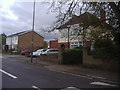
West Molesey: Molesey Road Coal & Wine Tax Post
The post is on the east side of Molesey Road, just to the north of the junction with Pool Road. For a close-up please see Image For a very comprehensive and interesting history of these posts please refer to Elmbridge Borough Council's dedicated website page here http://www.elmbridge.gov.uk/Tourism/coalwine.htm
Image: © Nigel Cox
Taken: 13 Aug 2008
0.07 miles
6
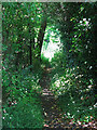
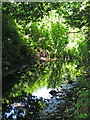
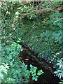
Footpath by the Dead River south of Fleetside
Image: © Mike Quinn
Taken: 6 Jun 2018
0.08 miles
9
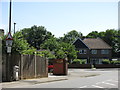
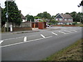
Molesey Road / Pool Road (2)
Shows the location of Image
Image: © Mike Quinn
Taken: 6 Jun 2018
0.10 miles
10
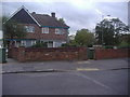
Coal tax boundary post no.100, Molesey Road / Pool Road
The location of this post is shown in Image, Image and Image
The post is Grade II listed https://historicengland.org.uk/listing/the-list/list-entry/1190896 .
There are over 200 coal tax posts located around London, most of which are 3 ft high white-painted bollards http://www.geograph.org.uk/search.php?i=86542993&page=1 . The posts were erected under the Coal and Wine Duties (Continuation) Act of 1861 to mark the points at which duty had to be paid on coal being transported to London. The boundary was set at that of the Metropolitan Police District, and the resulting revenue was used by the Corporation of the City of London to fund public works. For further info see http://www.coaldutyposts.org.uk/cityposts.html .
Image: © Mike Quinn
Taken: 6 Jun 2018
0.10 miles