IMAGES TAKEN NEAR TO
Molesey Park Road, EAST MOLESEY, KT8 0DB
Introduction
This page details the photographs taken nearby to Molesey Park Road, KT8 0DB by members of the Geograph project.
The Geograph project started in 2005 with the aim of publishing, organising and preserving representative images for every square kilometre of Great Britain, Ireland and the Isle of Man.

There are currently over 7.5m images from over14,400 individuals and you can help contribute to the project by visiting https://www.geograph.org.uk
Image Map
Images are licensed for reuse under creativecommons.org/licenses/by-sa/2.0
Notes
- Clicking on the map will re-center to the selected point.
- The higher the marker number, the further away the image location is from the centre of the postcode.
Image Listing (60 Images Found)
Images are licensed for reuse under creativecommons.org/licenses/by-sa/2.0
Image
Details
Distance
1
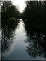
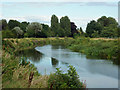
The River Mole at East Molesey: mirror water
Looking upstream from the bridge at the southern end of Bell Road and Spencer Road. Although it was early April, about the only colour in this shot is contributed by the green banks of Island Barn reservoir - just visible in the distance. They account for the high horizon.
I'm no angler, but I like the expression 'mirror water' which I've heard used by fly-fishermen to describe dead-calm conditions like these. Definitely the time to be out with your camera.
Image: © Stefan Czapski
Taken: 5 Apr 2007
0.02 miles
2
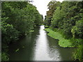
River Mole in East Molesey (1)
Viewed looking upstream from Tanner's Bridge.
Image: © Nigel Cox
Taken: 13 Aug 2008
0.05 miles
3
The River Ember east of Island Barn Reservoir (2)
This section of the river is an artificial channel built in the early 1980s - see https://en.wikipedia.org/wiki/River_Ember and Image (photographed by Michael Parry). Shows the location of Image (right).
Image: © Mike Quinn
Taken: 6 Jun 2018
0.07 miles
4
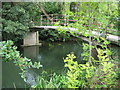
River Mole: Tanner's Bridge
Tanner's Bridge carries a public footpath between East Molesey and Thames Ditton over the River Mole.
Image: © Nigel Cox
Taken: 13 Aug 2008
0.07 miles
5
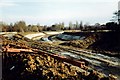
River Ember Flood Relief Scheme
A new river under construction.
Image: © Michael Parry
Taken: Unknown
0.07 miles
6
River Ember, East Molesey
An artificial channel constructed as a flood relief measure in the 1980s - see Image] .
Image: © Robin Webster
Taken: 26 Aug 2012
0.08 miles
7
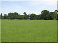
Recreation ground between the rivers Mole and Ember
Image: © Mike Quinn
Taken: 6 Jun 2018
0.08 miles
8
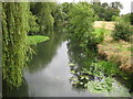
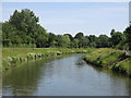
River Mole in East Molesey (2)
Viewed looking downstream from Tanner's Bridge. At this point the Rivers Mole and Ember run so close to one another that the Ember is only just out of sight beyond the hedge on the far right.
Image: © Nigel Cox
Taken: 13 Aug 2008
0.10 miles
9

Confluence of the River Ember and its off-shoot
See Image
Image: © Mike Quinn
Taken: 6 Jun 2018
0.10 miles
