IMAGES TAKEN NEAR TO
Cholmley Road, THAMES DITTON, KT7 0XT
Introduction
This page details the photographs taken nearby to Cholmley Road, KT7 0XT by members of the Geograph project.
The Geograph project started in 2005 with the aim of publishing, organising and preserving representative images for every square kilometre of Great Britain, Ireland and the Isle of Man.

There are currently over 7.5m images from over14,400 individuals and you can help contribute to the project by visiting https://www.geograph.org.uk
Image Map
Images are licensed for reuse under creativecommons.org/licenses/by-sa/2.0
Notes
- Clicking on the map will re-center to the selected point.
- The higher the marker number, the further away the image location is from the centre of the postcode.
Image Listing (87 Images Found)
Images are licensed for reuse under creativecommons.org/licenses/by-sa/2.0
Image
Details
Distance
1
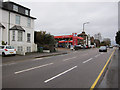
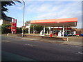
Petrol station, Portsmouth Road
Compare prices with Image Rising petrol prices, now over £1.30 a litre, have caused financial problems for many people reliant of their car for commuting or who don't need to use it but do anyway. At the same time many people still drive inefficiently with excessive acceleration, late braking and high speeds on main roads. these may or may not be the same people complaining about how much petrol costs.
Image: © Hugh Venables
Taken: 31 Dec 2011
0.03 miles
2
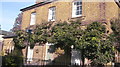
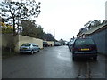
The Old Police Station, Ferry Road, Winters Bridge
Image: © Graham Howard
Taken: 27 Oct 2010
0.03 miles
3
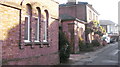
The Old Police Station, Ferry Road, Winters Bridge (cell block in foreground)
Image: © Graham Howard
Taken: 27 Oct 2010
0.03 miles
5
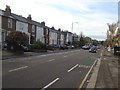
Ferry Road, Thames Ditton
It's a very long time since a ferry ran from here, as with a few more similarly named roads along the river.
Image: © David Howard
Taken: 13 Oct 2014
0.05 miles
6
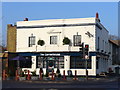
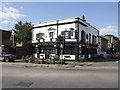
The Cornerhouse
Ditton pub on corner of Ferry and Portsmouth Roads, recently re-opened in time for Christmas. Earlier this year it was called the "Ferry Tavern". Years ago it was named the "Essex Arms".
Image: © Colin Smith
Taken: 21 Dec 2007
0.05 miles
7
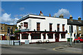
The Ferry, Thames Ditton
The latest guise for this pub, mapped in 1956 as the 'Essex Arms' later 'The Ferry Tavern' (Image), briefly 'The Cornerhouse' (Image) and now 'The Ferry'. It is on the corner of Ferry Road, which used to lead down to a ferry, which is no more.
Image: © Robin Webster
Taken: 26 Aug 2012
0.06 miles
9
Ferry Tavern, Thames Ditton
The shutters aren't up yet but its future in doubt
Image: © al partington
Taken: 10 Sep 2007
0.06 miles
10
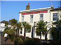
Tiger Joe's, Long Ditton
Pub on corner of Portsmouth and Thorkhill Roads, with a number of palm trees surrounding it.
Image: © Colin Smith
Taken: 21 Dec 2007
0.06 miles