IMAGES TAKEN NEAR TO
Dennan Road, SURBITON, KT6 7RY
Introduction
This page details the photographs taken nearby to Dennan Road, KT6 7RY by members of the Geograph project.
The Geograph project started in 2005 with the aim of publishing, organising and preserving representative images for every square kilometre of Great Britain, Ireland and the Isle of Man.

There are currently over 7.5m images from over14,400 individuals and you can help contribute to the project by visiting https://www.geograph.org.uk
Image Map
Images are licensed for reuse under creativecommons.org/licenses/by-sa/2.0
Notes
- Clicking on the map will re-center to the selected point.
- The higher the marker number, the further away the image location is from the centre of the postcode.
Image Listing (52 Images Found)
Images are licensed for reuse under creativecommons.org/licenses/by-sa/2.0
Image
Details
Distance
1
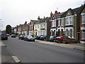
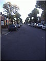
Surbiton: Ellerton Road
Houses on the west side of Ellerton Road.
Image: © Nigel Cox
Taken: 16 Mar 2006
0.08 miles
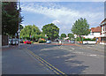
2
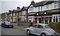
Douglas Road, Tolworth
Typical Victorian Road of the area.
Image: © David Howard
Taken: 25 Oct 2009
0.11 miles
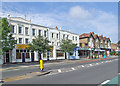
3
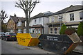
Houses on Douglas Rd
These large waste skips are outside some victorian semi detached houses being renovated just south of the Ewell Rd the A240.
Image: © Nigel Mykura
Taken: 3 Dec 2015
0.11 miles
4
Houses on Tolworth Park Rd
This row of red brick terraced houses is on the north side of Tolworth Park Rd at the junction with Bond Rd.
Image: © Nigel Mykura
Taken: 3 Dec 2015
0.13 miles
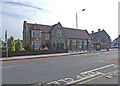
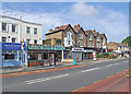
7
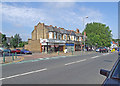
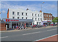
Ewell Road shops
At the junction with Worthington Road.
Image: © Dennis Turner
Taken: 27 Jun 2009
0.16 miles