IMAGES TAKEN NEAR TO
Hook Rise South, SURBITON, KT6 7LW
Introduction
This page details the photographs taken nearby to Hook Rise South, KT6 7LW by members of the Geograph project.
The Geograph project started in 2005 with the aim of publishing, organising and preserving representative images for every square kilometre of Great Britain, Ireland and the Isle of Man.

There are currently over 7.5m images from over14,400 individuals and you can help contribute to the project by visiting https://www.geograph.org.uk
Image Map
Images are licensed for reuse under creativecommons.org/licenses/by-sa/2.0
Notes
- Clicking on the map will re-center to the selected point.
- The higher the marker number, the further away the image location is from the centre of the postcode.
Image Listing (46 Images Found)
Images are licensed for reuse under creativecommons.org/licenses/by-sa/2.0
Image
Details
Distance
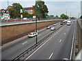
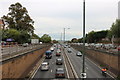
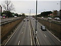
2
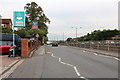
Hook underpass
Eastern approach on the A3 trunk route, to the Hook underpass and slip road.
Image: © Dennis Turner
Taken: 20 Aug 2005
0.03 miles
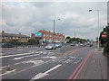
6
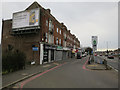
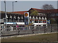
Shops by the A3
Including a bulk photo scanning centre.
Image: © Hugh Venables
Taken: 30 Dec 2015
0.10 miles
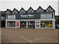
10
Ace of Spades, Hook
Mock Tudor gables above a shopping parade at the Ace of Spades roundabout on the Kingston By-Pass.
http://en.wikipedia.org/wiki/Hook,_London
Image: © Colin Smith
Taken: 23 Mar 2012
0.11 miles