IMAGES TAKEN NEAR TO
Ewell Road, SURBITON, KT6 7BA
Introduction
This page details the photographs taken nearby to Ewell Road, KT6 7BA by members of the Geograph project.
The Geograph project started in 2005 with the aim of publishing, organising and preserving representative images for every square kilometre of Great Britain, Ireland and the Isle of Man.

There are currently over 7.5m images from over14,400 individuals and you can help contribute to the project by visiting https://www.geograph.org.uk
Image Map
Images are licensed for reuse under creativecommons.org/licenses/by-sa/2.0
Notes
- Clicking on the map will re-center to the selected point.
- The higher the marker number, the further away the image location is from the centre of the postcode.
Image Listing (85 Images Found)
Images are licensed for reuse under creativecommons.org/licenses/by-sa/2.0
Image
Details
Distance
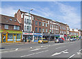
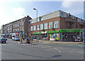
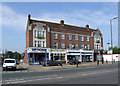
1
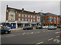
Shops on Ewell Road
Image: © Hugh Venables
Taken: 30 Dec 2015
0.01 miles
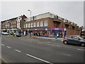
2
Former Red Lion
Closed and awaiting re-development.
Image: © Dennis Turner
Taken: 27 Jun 2009
0.01 miles
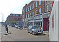
4
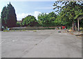
Awaiting re-development
Grounds of the former Red Lion public house.
Image: © Dennis Turner
Taken: 27 Jun 2009
0.01 miles
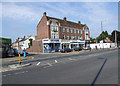
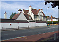
8
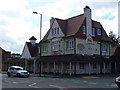
The Red Lion, Tolworth
This old pub, on the corner of Ewell and Red Lion Roads, was built in 1906. It became a part of the Harvester chain of restaurants ca 1995 before it was closed in summer 2007. The Red Lion was then demolished and flats were built on the site.
Image: © Colin Smith
Taken: 27 Jul 2007
0.02 miles