IMAGES TAKEN NEAR TO
Ewell Road, SURBITON, KT6 7AA
Introduction
This page details the photographs taken nearby to Ewell Road, KT6 7AA by members of the Geograph project.
The Geograph project started in 2005 with the aim of publishing, organising and preserving representative images for every square kilometre of Great Britain, Ireland and the Isle of Man.

There are currently over 7.5m images from over14,400 individuals and you can help contribute to the project by visiting https://www.geograph.org.uk
Image Map
Images are licensed for reuse under creativecommons.org/licenses/by-sa/2.0
Notes
- Clicking on the map will re-center to the selected point.
- The higher the marker number, the further away the image location is from the centre of the postcode.
Image Listing (68 Images Found)
Images are licensed for reuse under creativecommons.org/licenses/by-sa/2.0
Image
Details
Distance
1
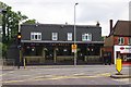
The Royal Oak, 261 Ewell Road, Surbiton
Traditional public house with beer, food and a beer garden.
Image: © P L Chadwick
Taken: 18 Aug 2013
0.02 miles
2
The Royal Oak
Traditional pub in Ewell Road, Tolworth. Former landlords were Fred Mudd of "Mudlarks" pop fame and his wife, former Blue Peter and Miss England fame. The pub has since been recently refurbished and is one of the few remaining in Tolworth.
Image: © Colin Smith
Taken: 16 May 2008
0.02 miles
3
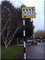
Pre-Worboys sign Tolworth
On the corner of Ditton Road and Ewell Road, this sign and pole have been restored to original condition by Kingston Council and serve as an example to all.
Image: © David Howard
Taken: 12 Jan 2009
0.02 miles
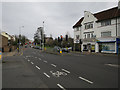
4
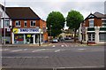
Junction of Ewell Road & Beaconsfield Road, Surbiton
On the left at 265 Ewell Road is Sunbed Studios, a tanning studio. On the right at 269 Ewell Road is Gino's Deli, a sandwich shop and delicatessen. Beaconsfield Road is mainly residential. It has two very large trees near the junction.
Image: © P L Chadwick
Taken: 18 Aug 2013
0.03 miles
5

Bygone Days in Tolworth
In a small garden in Ditton Road is this old water trough, now put to a different use to suit the current times. Does this include deposition of empty beer bottles?
Image: © Colin Smith
Taken: 18 Nov 2011
0.03 miles
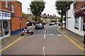
7
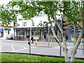
Ewell Road
At the junction with Hollyfield Road.
Image: © Dennis Turner
Taken: 27 Jun 2009
0.04 miles
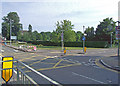
8
Ewell Road
At the junction with Ditton Road.
Image: © Dennis Turner
Taken: 27 Jun 2009
0.04 miles
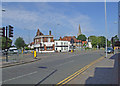
10
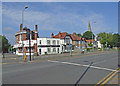
Ewell Road
Between Ditton Road on the left and Kingsdowne Road on right. The spire of St Matthew's church on the right of the picture.
Image: © Dennis Turner
Taken: 27 Jun 2009
0.05 miles