IMAGES TAKEN NEAR TO
Mayfair Close, SURBITON, KT6 6RR
Introduction
This page details the photographs taken nearby to Mayfair Close, KT6 6RR by members of the Geograph project.
The Geograph project started in 2005 with the aim of publishing, organising and preserving representative images for every square kilometre of Great Britain, Ireland and the Isle of Man.

There are currently over 7.5m images from over14,400 individuals and you can help contribute to the project by visiting https://www.geograph.org.uk
Image Map
Images are licensed for reuse under creativecommons.org/licenses/by-sa/2.0
Notes
- Clicking on the map will re-center to the selected point.
- The higher the marker number, the further away the image location is from the centre of the postcode.
Image Listing (35 Images Found)
Images are licensed for reuse under creativecommons.org/licenses/by-sa/2.0
Image
Details
Distance
2
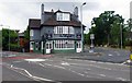
The Maypole (1), 2 Hook Road, Surbiton
This public house is located on the corner of Hook Road and Ditton Road. It has homemade food, a beer garden and accommodation available. It can also host small functions.
Image
Image: © P L Chadwick
Taken: 18 Aug 2013
0.07 miles
3

The Maypole (2) - sign, 2 Hook Road, Surbiton
The sign shows the top of a traditional maypole around which dancing often took place on May Day. The sign is on a pole at the side of the garden, adjacent to Hook Road.
Image
Image: © P L Chadwick
Taken: 18 Aug 2013
0.07 miles
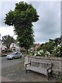
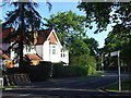
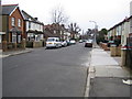
5
Southborough Road, Surbiton
Tree-lined residential road in the upmarket area of Surbiton, Kingston-upon-Thames.
Image: © Colin Smith
Taken: 18 Nov 2011
0.12 miles
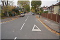
6
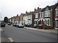
Surbiton: Ellerton Road
Houses on the west side of Ellerton Road.
Image: © Nigel Cox
Taken: 16 Mar 2006
0.13 miles
7
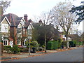
House in Southborough
This is in a tree lined estate and is at the junction of Ashcombe Ave and Southborough Rd with Langley Ave in Southborough, 4km South of Kingston on Thames
Image: © steve
Taken: 4 Aug 2005
0.18 miles
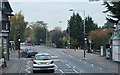
8
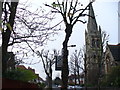
St Matthew's Avenue
Residential tree-lined street and tall church spire in the Surbiton-Tolworth fringe.
Image: © Colin Smith
Taken: 12 Dec 2008
0.19 miles
9
Surbiton: Cotterill Road
Viewed looking north with the spire of St Matthew's Church just visible over the trees.
Image: © Nigel Cox
Taken: 16 Mar 2006
0.19 miles