IMAGES TAKEN NEAR TO
Croylands Drive, SURBITON, KT6 6LF
Introduction
This page details the photographs taken nearby to Croylands Drive, KT6 6LF by members of the Geograph project.
The Geograph project started in 2005 with the aim of publishing, organising and preserving representative images for every square kilometre of Great Britain, Ireland and the Isle of Man.

There are currently over 7.5m images from over14,400 individuals and you can help contribute to the project by visiting https://www.geograph.org.uk
Image Map
Images are licensed for reuse under creativecommons.org/licenses/by-sa/2.0
Notes
- Clicking on the map will re-center to the selected point.
- The higher the marker number, the further away the image location is from the centre of the postcode.
Image Listing (45 Images Found)
Images are licensed for reuse under creativecommons.org/licenses/by-sa/2.0
Image
Details
Distance
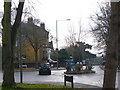
6
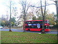
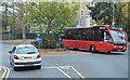
Upper Brighton Road, Surbiton
Chessington-bound bus in an upmarket area of tree-lined roads and large houses broken down into apartments.
Image: © Colin Smith
Taken: 18 Nov 2011
0.11 miles
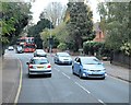
7
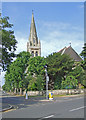
St Matthew's Avenue
View from Kingsdowne Road
Image: © Dennis Turner
Taken: 27 Jun 2009
0.11 miles
8
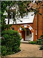
House entrance, Langley Avenue (2)
A house at the north-eastern end of Langley Avenue, near to the junction with the Upper Brighton Road. The overall style of the house reminds me of Bedford Park (West London) but the porch - in the form of a segment of a circle - is rather unusual (I'm reminded of the Piccadilly Line).
At a guess, the architect may well have been one of those involved in the Bedford Park project, under the supervision of Norman Shaw.
Image: © Stefan Czapski
Taken: 30 May 2013
0.12 miles
9
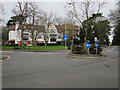
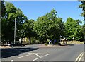
Upper Brighton Road
Roundabout in the middle of a hilltop road junction between Hook and Surbiton. The large detached house is typical of the area, subdivided into flats.
Image: © Colin Smith
Taken: 12 Dec 2008
0.13 miles
10
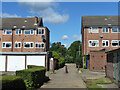
Path from Oakenshaw Close to Oak Hill, Surbiton
Image: © Robin Webster
Taken: 26 Aug 2012
0.13 miles