IMAGES TAKEN NEAR TO
Chamberlain Way, SURBITON, KT6 6JH
Introduction
This page details the photographs taken nearby to Chamberlain Way, KT6 6JH by members of the Geograph project.
The Geograph project started in 2005 with the aim of publishing, organising and preserving representative images for every square kilometre of Great Britain, Ireland and the Isle of Man.

There are currently over 7.5m images from over14,400 individuals and you can help contribute to the project by visiting https://www.geograph.org.uk
Image Map
Images are licensed for reuse under creativecommons.org/licenses/by-sa/2.0
Notes
- Clicking on the map will re-center to the selected point.
- The higher the marker number, the further away the image location is from the centre of the postcode.
Image Listing (70 Images Found)
Images are licensed for reuse under creativecommons.org/licenses/by-sa/2.0
Image
Details
Distance
1
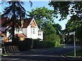
House in Southborough
This is in a tree lined estate and is at the junction of Ashcombe Ave and Southborough Rd with Langley Ave in Southborough, 4km South of Kingston on Thames
Image: © steve
Taken: 4 Aug 2005
0.03 miles
6
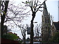
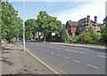
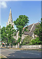
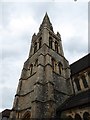
St Matthew's Avenue
Residential tree-lined street and tall church spire in the Surbiton-Tolworth fringe.
Image: © Colin Smith
Taken: 12 Dec 2008
0.08 miles

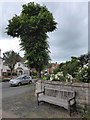
9

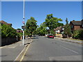
Kingsdowne Road
Tree-lined residential road and through route connecting Surbiton and Tolworth.
Image: © Colin Smith
Taken: 18 Nov 2011
0.08 miles