IMAGES TAKEN NEAR TO
Oak Hill Grove, SURBITON, KT6 6DS
Introduction
This page details the photographs taken nearby to Oak Hill Grove, KT6 6DS by members of the Geograph project.
The Geograph project started in 2005 with the aim of publishing, organising and preserving representative images for every square kilometre of Great Britain, Ireland and the Isle of Man.

There are currently over 7.5m images from over14,400 individuals and you can help contribute to the project by visiting https://www.geograph.org.uk
Image Map
Images are licensed for reuse under creativecommons.org/licenses/by-sa/2.0
Notes
- Clicking on the map will re-center to the selected point.
- The higher the marker number, the further away the image location is from the centre of the postcode.
Image Listing (122 Images Found)
Images are licensed for reuse under creativecommons.org/licenses/by-sa/2.0
Image
Details
Distance
1
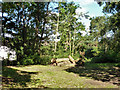
Logs in The Wood
A very small public open space.
Image: © Robin Webster
Taken: 26 Aug 2012
0.03 miles
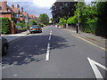
4
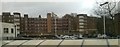
3 Oak Hill, Surbiton, 2012
Presenting an unattractive side view, this block of flats has since been demolished and replaced with another block of flats, pretending externally to be of similar vintage.
Image: © Robin Webster
Taken: 26 Aug 2012
0.09 miles
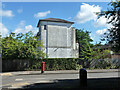
10
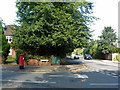
Postbox, Lovelace Road
At the junction with Upper Brighton Road is this Victorian pillarbox, number KT6 50.
Image: © Robin Webster
Taken: 26 Aug 2012
0.12 miles