IMAGES TAKEN NEAR TO
Ewell Road, SURBITON, KT6 6BE
Introduction
This page details the photographs taken nearby to Ewell Road, KT6 6BE by members of the Geograph project.
The Geograph project started in 2005 with the aim of publishing, organising and preserving representative images for every square kilometre of Great Britain, Ireland and the Isle of Man.

There are currently over 7.5m images from over14,400 individuals and you can help contribute to the project by visiting https://www.geograph.org.uk
Image Map
Images are licensed for reuse under creativecommons.org/licenses/by-sa/2.0
Notes
- Clicking on the map will re-center to the selected point.
- The higher the marker number, the further away the image location is from the centre of the postcode.
Image Listing (83 Images Found)
Images are licensed for reuse under creativecommons.org/licenses/by-sa/2.0
Image
Details
Distance
1
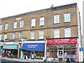
The Pavement, Ewell Road
A brick-built block of flats with a variety of shops at ground level.
Image: © Colin Smith
Taken: 12 Dec 2008
0.01 miles

3

Fog on Ewell Road, Surbiton
This was the worst day of fog London had seen for many years. There are buildings there but you can't see them.
Image: © David Howard
Taken: 1 Nov 2015
0.03 miles
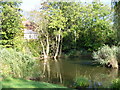
4
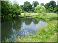
Fishponds Park
Fishponds Park contains three ponds, a stream and an area of grassland now managed as a hay meadow. On a map of 1762 this site is shown as a brick kiln and was part of Kingston Common, which stretched between Hook, Tolworth and Surbiton. By 1839 most of the land had been taken over as allotments, although a brickworks is still shown on the 1867 Ordnance Survey Map. Fishponds itself is a plain Georgian house built in 1742.
This is one of the smaller ponds.
Image: © Marathon
Taken: 10 Jul 2013
0.06 miles
5
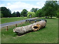
Carved tree trunk in Fishponds Park
Fishponds Park contains three ponds, a stream and an area of grassland now managed as a hay meadow. On a map of 1762 this site is shown as a brick kiln and was part of Kingston Common, which stretched between Hook, Tolworth and Surbiton. By 1839 most of the land had been taken over as allotments, although a brickworks is still shown on the 1867 Ordnance Survey Map. Fishponds itself is a plain Georgian house built in 1742.
I am unsure if this carved tree trunk has been damaged or was originally standing up.
Image: © Marathon
Taken: 10 Jul 2013
0.08 miles
7
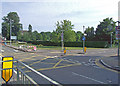
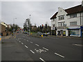
Ewell Road
At the junction with Hollyfield Road.
Image: © Dennis Turner
Taken: 27 Jun 2009
0.09 miles
9
Fishponds Park, Tolworth
Reflections in the pond in this small suburban park.
Image: © Colin Smith
Taken: 8 Oct 2006
0.09 miles
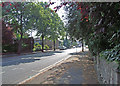
10

Kingsdowne Road
Tree-lined residential road and through route connecting Surbiton and Tolworth.
Image: © Colin Smith
Taken: 18 Nov 2011
0.09 miles