IMAGES TAKEN NEAR TO
St. James' Road, SURBITON, KT6 4QL
Introduction
This page details the photographs taken nearby to St. James' Road, KT6 4QL by members of the Geograph project.
The Geograph project started in 2005 with the aim of publishing, organising and preserving representative images for every square kilometre of Great Britain, Ireland and the Isle of Man.

There are currently over 7.5m images from over14,400 individuals and you can help contribute to the project by visiting https://www.geograph.org.uk
Image Map
Images are licensed for reuse under creativecommons.org/licenses/by-sa/2.0
Notes
- Clicking on the map will re-center to the selected point.
- The higher the marker number, the further away the image location is from the centre of the postcode.
Image Listing (164 Images Found)
Images are licensed for reuse under creativecommons.org/licenses/by-sa/2.0
Image
Details
Distance
1
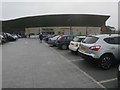
Surbiton Waitrose
From the car park, which also has a lower layer.
Image: © Hugh Venables
Taken: 12 Mar 2016
0.05 miles
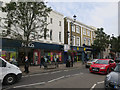
3
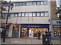
Cancer Research shop on Victoria Road, Surbiton
Image: © David Howard
Taken: 6 Nov 2016
0.08 miles
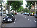
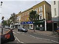
4
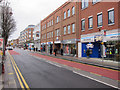
Victoria Road, Surbiton
Close to the station.
Image: © Hugh Venables
Taken: 31 Dec 2011
0.08 miles
6
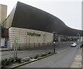
Waitrose, Surbiton
One of two supermarkets in Surbiton, there also being a Sainsbury's.
Image: © Hugh Venables
Taken: 12 Mar 2016
0.08 miles
7
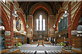
St Andrew, Maple Road, Surbiton - Chancel
Image: © John Salmon
Taken: 11 May 2010
0.08 miles
8

St Andrew, Maple Road, Surbiton - Memorial WWI
Image: © John Salmon
Taken: 11 May 2010
0.08 miles
10

Claremont Road, Surbiton
Claremont is a country house and park in nearby Esher, which may be where this street name comes from.
Image: © Des Blenkinsopp
Taken: 14 Jul 2016
0.08 miles