IMAGES TAKEN NEAR TO
St. Mark's Hill, SURBITON, KT6 4PX
Introduction
This page details the photographs taken nearby to St. Mark's Hill, KT6 4PX by members of the Geograph project.
The Geograph project started in 2005 with the aim of publishing, organising and preserving representative images for every square kilometre of Great Britain, Ireland and the Isle of Man.

There are currently over 7.5m images from over14,400 individuals and you can help contribute to the project by visiting https://www.geograph.org.uk
Image Map (Loading...)


Getting Data...Please wait
Leaflet Map data © OpenStreetMap
Images are licensed for reuse under creativecommons.org/licenses/by-sa/2.0
Notes
- Clicking on the map will re-center to the selected point.
- The higher the marker number, the further away the image location is from the centre of the postcode.
Image Listing (133 Images Found)
Images are licensed for reuse under creativecommons.org/licenses/by-sa/2.0
Image
Details
Distance
1
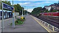
Surbiton station - view east from platform 2
Image: © Peter Whatley
Taken: 28 Jul 2023
0.03 miles
3
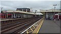
Surbiton station looking east from platform 3
The layout of tracks is slightly unusual, with a through, non-platform, line provided only on the Down Fast line, while the (eastbound) Up Fast passes through platform 2.
Image: © Peter Whatley
Taken: 28 Jul 2023
0.04 miles
7
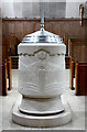
St Mark, St Marks Hill, Surbiton - Font
Image: © John Salmon
Taken: 11 May 2010
0.04 miles
8
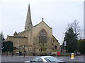
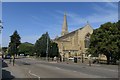
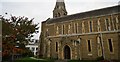
St Mark's Church
Landmark Surbiton church at the corner of Church and St Mark's Hills.
Image: © Colin Smith
Taken: 12 Dec 2008
0.05 miles
10

St Mark, St Marks Hill, Surbiton, Surrey
Image: © John Salmon
Taken: 11 May 2010
0.05 miles