IMAGES TAKEN NEAR TO
Grove Road, SURBITON, KT6 4DP
Introduction
This page details the photographs taken nearby to Grove Road, KT6 4DP by members of the Geograph project.
The Geograph project started in 2005 with the aim of publishing, organising and preserving representative images for every square kilometre of Great Britain, Ireland and the Isle of Man.

There are currently over 7.5m images from over14,400 individuals and you can help contribute to the project by visiting https://www.geograph.org.uk
Image Map
Images are licensed for reuse under creativecommons.org/licenses/by-sa/2.0
Notes
- Clicking on the map will re-center to the selected point.
- The higher the marker number, the further away the image location is from the centre of the postcode.
Image Listing (106 Images Found)
Images are licensed for reuse under creativecommons.org/licenses/by-sa/2.0
Image
Details
Distance
1

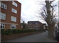
Surbiton - Thames Haven
Flats on Grove Road near the Thames.
Image: © James Emmans
Taken: 24 Jul 2016
0.08 miles
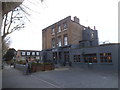
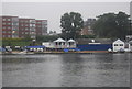
2
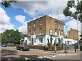
The Grove
A very square looking pub on the corner of Grove Road.
It looks like it was once part of a larger development.
Image: © Des Blenkinsopp
Taken: 14 Jul 2016
0.08 miles
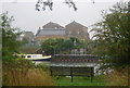
5
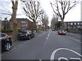
Maple Road, Surbiton
A relatively rare straight road in Britain. They are definitely the exception and not the rule.
Image: © David Howard
Taken: 23 Mar 2015
0.09 miles
10
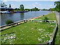
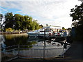
Queen?s Promenade looking across to Ravens Ait
Queen’s Promenade was opened by Queen Victoria in 1856 when she drove along the rebuilt Town’s End Road on her way back from a visit to Claremont at Esher. One thousand schoolchildren lined the road, which had been renamed Queen’s Parade. It is now known as Portsmouth Road. Before the 1850s the river banks had been worked for gravel, and the old road was undermined. William Woods, a local builder, undertook to provide a promenade from Raven’s Ait to St Raphael’s Church, if the Corporation would complete it up to the High Street.
This view looks across to Ravens Ait from near the southern end of Queen's Promenade, where the Thames Path leaves the river to go around Seething Wells. The word 'ait' denotes an island along this part of the Thames. Many of the aits are left to nature but Ravens Ait is more built up with the Ravens Ait Watersports Centre.
Image: © Marathon
Taken: 5 Jun 2013
0.12 miles