IMAGES TAKEN NEAR TO
Alpine Avenue, SURBITON, KT5 9RL
Introduction
This page details the photographs taken nearby to Alpine Avenue, KT5 9RL by members of the Geograph project.
The Geograph project started in 2005 with the aim of publishing, organising and preserving representative images for every square kilometre of Great Britain, Ireland and the Isle of Man.

There are currently over 7.5m images from over14,400 individuals and you can help contribute to the project by visiting https://www.geograph.org.uk
Image Map
Images are licensed for reuse under creativecommons.org/licenses/by-sa/2.0
Notes
- Clicking on the map will re-center to the selected point.
- The higher the marker number, the further away the image location is from the centre of the postcode.
Image Listing (30 Images Found)
Images are licensed for reuse under creativecommons.org/licenses/by-sa/2.0
Image
Details
Distance
1
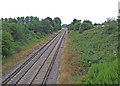
The Chessington line
View from Knollmead bridge of the Waterloo to Chessington railway line.
Image: © Dennis Turner
Taken: 28 Jun 2009
0.05 miles
2
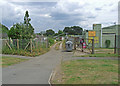
Knollmead Primary School
Situated south of the Waterloo to Chessington railway line the school serves the inter war built Sunray housing estate.
Image: © Dennis Turner
Taken: 28 Jun 2009
0.06 miles
3
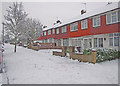
Hazelbank
One of the tree lined streets on the inter war built Sunray housing development situated between the Waterloo and Chessington railway line and the A3 at Tolworth.
Image: © Dennis Turner
Taken: 28 Jun 2009
0.07 miles
4
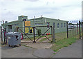
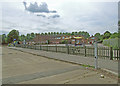
Social club
Sunray Residents Association social club south of Knollmead railway bridge.
Image: © Dennis Turner
Taken: 28 Jun 2009
0.07 miles

6

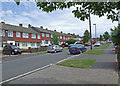
Hazelbank
One of the tree lined streets on the inter war built Sunray housing development situated between the Waterloo and Chessington railway line and the A3 at Tolworth.
Image: © Dennis Turner
Taken: 28 Jun 2009
0.09 miles
7
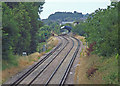
The Chessington line
View from Knollmead bridge of the Waterloo to Chessington railway line. The station in the distance is Tolworth.
Image: © Dennis Turner
Taken: 28 Jun 2009
0.09 miles
8
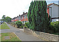
Hazelbank
One of the tree lined streets on the inter war years built Sunray housing development situated between the Waterloo and Chessington railway line and the A3 at Tolworth.
Image: © Dennis Turner
Taken: 27 Jun 2009
0.09 miles
9
Sunray allotments
Allotments adjacent to Sunray Residents Association social club south of Knollmead railway bridge.
Image: © Dennis Turner
Taken: 28 Jun 2009
0.10 miles