IMAGES TAKEN NEAR TO
Beresford Avenue, SURBITON, KT5 9LJ
Introduction
This page details the photographs taken nearby to Beresford Avenue, KT5 9LJ by members of the Geograph project.
The Geograph project started in 2005 with the aim of publishing, organising and preserving representative images for every square kilometre of Great Britain, Ireland and the Isle of Man.

There are currently over 7.5m images from over14,400 individuals and you can help contribute to the project by visiting https://www.geograph.org.uk
Image Map
Images are licensed for reuse under creativecommons.org/licenses/by-sa/2.0
Notes
- Clicking on the map will re-center to the selected point.
- The higher the marker number, the further away the image location is from the centre of the postcode.
Image Listing (18 Images Found)
Images are licensed for reuse under creativecommons.org/licenses/by-sa/2.0
Image
Details
Distance
1
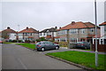
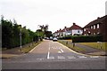
Houses on Beresford Avenue (2)
Beresford Avenue runs from Elmbridge Ave in the north to Warren Drive North in the south. These 1930's semi detached and detached houses are close to the southern end just west of Lyndhurst Avenue.
Image: © Nigel Mykura
Taken: 3 Dec 2015
0.06 miles
2
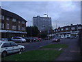
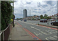
Raeburn Avenue Tolworth
Junction with Ewell Road and Tolworth Tower in the background
Image: © David Howard
Taken: 18 Jan 2010
0.12 miles
3
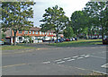
Warren Drive South
At junction with Tolworth Rise South. One of the tree lined streets on the inter war years built Sunray housing development situated between the Waterloo and Chessington railway line and the A3 at Tolworth.
Image: © Dennis Turner
Taken: 28 Jun 2009
0.15 miles
4
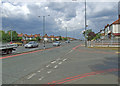
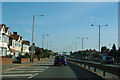
Kingston Bypass
At junction with Tolworth Rise South and Warren Drive South.
Image: © Dennis Turner
Taken: 28 Jun 2009
0.18 miles
5
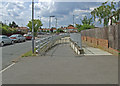
Slip road from A240 to A3
A very long slip, perhaps because it doubles as a residential access road.
Image: © Robin Webster
Taken: 1 Apr 2012
0.19 miles
6
Ewell Road Tolworth
Looking towards the Broadway
Image: © David Howard
Taken: 18 Jan 2010
0.19 miles
7
Tolworth Rise South
Slip road from the former service road to houses on the Kingston Bypass. The ubiquitous Tolworth Tower dominating the skyline.
Image: © Dennis Turner
Taken: 28 Jun 2009
0.19 miles
8
Barnsbury Crescent
One of the tree lined streets on the inter war years built Sunray housing development situated between the Waterloo and Chessington railway line and the A3 at Tolworth.
Image: © Dennis Turner
Taken: 27 Jun 2009
0.21 miles
9
Fairmead, Tolworth
A residential road, off Ewell Road.
Image: © P L Chadwick
Taken: 26 Jul 2015
0.22 miles
10
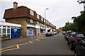
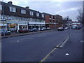
Ewell Road, Tolworth
Several of the ground floor shops in this road appear to have been converted into residential accommodation. The single-storey building on the left is Tolworth Ambulance Station.
Image
Image: © P L Chadwick
Taken: 26 Jul 2015
0.22 miles