IMAGES TAKEN NEAR TO
Grand Avenue, SURBITON, KT5 9HZ
Introduction
This page details the photographs taken nearby to Grand Avenue, KT5 9HZ by members of the Geograph project.
The Geograph project started in 2005 with the aim of publishing, organising and preserving representative images for every square kilometre of Great Britain, Ireland and the Isle of Man.

There are currently over 7.5m images from over14,400 individuals and you can help contribute to the project by visiting https://www.geograph.org.uk
Image Map (Loading...)


Getting Data...Please wait
Leaflet Map data © OpenStreetMap
Images are licensed for reuse under creativecommons.org/licenses/by-sa/2.0
Notes
- Clicking on the map will re-center to the selected point.
- The higher the marker number, the further away the image location is from the centre of the postcode.
Image Listing (68 Images Found)
Images are licensed for reuse under creativecommons.org/licenses/by-sa/2.0
Image
Details
Distance
3
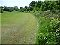
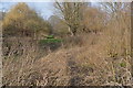
Raeburn Avenue Open Space
Raeburn Avenue Open Space consists of a network of elongated fields separated by overgrown hedgerows and strips of woodland. The Tolworth Brook runs through the open space. Its main source is near Claygate and it flows into the Hogsmill just downstream of Raeburn Avenue Open Space. The tithe map of 1839 shows Raeburn Avenue Open Space as meadow with mostly arable fields on either side out of reach of flooding, a land use that carried on well into the 20th century. The open space is surrounded by housing now, although this is by no means obvious when you walk through it, but it has been saved from development by virtue of being the floodplain of the Tolworth Brook.
Image: © Marathon
Taken: 5 Jun 2013
0.04 miles
4
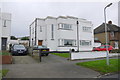
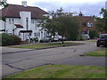
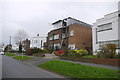
Art Deco Houses Elmbridge Avenue
This is a pair of Art Deco semi detached house on the west side of the street a short distance south of the junction with Grand Avenue.This is a cross rid photo as the easting grid line lies between the photographer and the house.
Image: © Nigel Mykura
Taken: 3 Dec 2015
0.04 miles
5
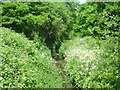
The Tolworth Brook flowing through Raeburn Avenue Open Space
Raeburn Avenue Open Space consists of a network of elongated fields separated by overgrown hedgerows and strips of woodland. The Tolworth Brook runs through the open space. Its main source is near Claygate and it flows into the Hogsmill just downstream of Raeburn Avenue Open Space. The tithe map of 1839 shows Raeburn Avenue Open Space as meadow with mostly arable fields on either side out of reach of flooding, a land use that carried on well into the 20th century. The open space is surrounded by housing now, although this is by no means obvious when you walk through it, but it has been saved from development by virtue of being the floodplain of the Tolworth Brook.
Image: © Marathon
Taken: 5 Jun 2013
0.06 miles
6
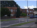
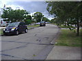
Modernist houses on Elmbridge Avenue, Berrylands
The basic difference between art deco and modernist, both popular in the 1930s but originated twenty years earlier in Germany, is modernist does not have curves.
Image: © David Howard
Taken: 12 Aug 2007
0.06 miles
7
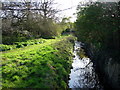
Stream through Berrylands
Tolworth Brook, a tributary of the Hogsmill.
Image: © Hugh Venables
Taken: 8 Apr 2006
0.08 miles
8
Houses on Elmbridge Avenue, Berrylands
Image: © David Howard
Taken: 12 Aug 2007
0.09 miles
9
Art Deco Houses Elmbridge Avenue (2)
The grid line runs through these houses at an acute angle so that the houses on the left half of the picture are in TQ2067 and those on the right are in TQ1967. The houses have flat roofs and it appears that one of the houses is being renovated.
Image: © Nigel Mykura
Taken: 3 Dec 2015
0.09 miles