IMAGES TAKEN NEAR TO
Elmbridge Avenue, SURBITON, KT5 9EZ
Introduction
This page details the photographs taken nearby to Elmbridge Avenue, KT5 9EZ by members of the Geograph project.
The Geograph project started in 2005 with the aim of publishing, organising and preserving representative images for every square kilometre of Great Britain, Ireland and the Isle of Man.

There are currently over 7.5m images from over14,400 individuals and you can help contribute to the project by visiting https://www.geograph.org.uk
Image Map
Images are licensed for reuse under creativecommons.org/licenses/by-sa/2.0
Notes
- Clicking on the map will re-center to the selected point.
- The higher the marker number, the further away the image location is from the centre of the postcode.
Image Listing (36 Images Found)
Images are licensed for reuse under creativecommons.org/licenses/by-sa/2.0
Image
Details
Distance
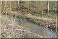
1
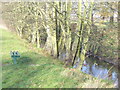
Hogsmill River Park
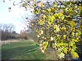
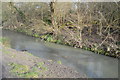
On the London Loop path which here follows the left bank of the Hogsmill River. Black spot disfigures the leaves on the tree.
www.surbiton.com
Image: © Colin Smith
Taken: 15 Dec 2011
0.10 miles
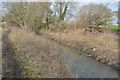
4
Riverbank, Hogsmill River Park
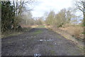
Popular area for recreation with the London Loop following the river here.
www.surbiton.com
Image: © Colin Smith
Taken: 15 Dec 2011
0.10 miles
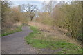
5
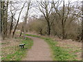
London LOOP path near Tolworth
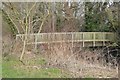
This path forms part of the London LOOP long-distance path in outer south west London.
Image: © Malc McDonald
Taken: 17 Feb 2019
0.10 miles