IMAGES TAKEN NEAR TO
King Charles Road, SURBITON, KT5 9BE
Introduction
This page details the photographs taken nearby to King Charles Road, KT5 9BE by members of the Geograph project.
The Geograph project started in 2005 with the aim of publishing, organising and preserving representative images for every square kilometre of Great Britain, Ireland and the Isle of Man.

There are currently over 7.5m images from over14,400 individuals and you can help contribute to the project by visiting https://www.geograph.org.uk
Image Map
Images are licensed for reuse under creativecommons.org/licenses/by-sa/2.0
Notes
- Clicking on the map will re-center to the selected point.
- The higher the marker number, the further away the image location is from the centre of the postcode.
Image Listing (73 Images Found)
Images are licensed for reuse under creativecommons.org/licenses/by-sa/2.0
Image
Details
Distance
1
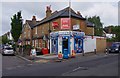
Beaconsfield Food & Wine, 99 Beaconsfield Road, Tolworth
A local convenience store including groceries, newsagents and an off-licence. It is located on the corner of Beaconsfield Road and King Charles Road.
Image: © P L Chadwick
Taken: 18 Aug 2013
0.03 miles
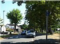
2
Alexandra Recreation Ground, King Charles Road, Tolworth
Part of the recreation ground which covers sixteen and a half acres.
Image: © P L Chadwick
Taken: 18 Aug 2013
0.08 miles
4
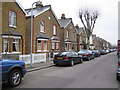
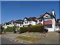
Surbiton: Beaconsfield Road
Neat Victorian semi-detached cottages on the north side of Beaconsfield Road.
Image: © Nigel Cox
Taken: 16 Mar 2006
0.09 miles
5
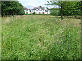
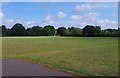
Hay meadow in Fishponds Park
Fishponds Park contains three ponds, a stream and an area of grassland now managed as a hay meadow. On a map of 1762 this site is shown as a brick kiln and was part of Kingston Common, which stretched between Hook, Tolworth and Surbiton. By 1839 most of the land had been taken over as allotments, although a brickworks is still shown on the 1867 Ordnance Survey Map. Fishponds itself is a plain Georgian house built in 1742.
This is the hay meadow looking towards the houses in King Charles Road. The purple flower in the foreground is knapweed.
Image: © Marathon
Taken: 10 Jul 2013
0.10 miles
6
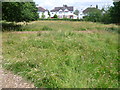
Hay meadow in Fishponds Park
Fishponds Park contains three ponds, a stream and an area of grassland now managed as a hay meadow. On a map of 1762 this site is shown as a brick kiln and was part of Kingston Common, which stretched between Hook, Tolworth and Surbiton. By 1839 most of the land had been taken over as allotments, although a brickworks is still shown on the 1867 Ordnance Survey Map. Fishponds itself is a plain Georgian house built in 1742.
This is the hay meadow looking towards the houses in King Charles Road.
Image: © Marathon
Taken: 10 Jul 2013
0.10 miles
7
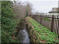
Tolworth Brook, Alexandra Recreation Ground
Image: © Hugh Venables
Taken: 30 Dec 2015
0.10 miles
9
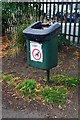
Dog waste bin, Alexandra Recreation Ground, King Charles Road, Tolworth
Located near an entrance from King Charles Road.
Image: © P L Chadwick
Taken: 18 Aug 2013
0.12 miles