1
Houses on Alexandra Drive, Surbiton
Image: © JThomas
Taken: 29 Jul 2022
0.09 miles
2
Entrance to Fishponds Park from King Charles Road, Tolworth
Fishponds Park is a small public park in the Royal Borough of Kingston upon Thames. Sometimes it is described as in Tolworth and sometimes as in Surbiton; the two areas being adjacent. The black bin is a litter bin and the red one is for dog waste.
Image: © P L Chadwick
Taken: 18 Aug 2013
0.10 miles
3
Alexandra Drive, Surbiton
Image: © JThomas
Taken: 29 Jul 2022
0.10 miles
4
Alexandra Drive, Surbiton
Image: © JThomas
Taken: 29 Jul 2022
0.11 miles
5
Hay meadow in Fishponds Park
Fishponds Park contains three ponds, a stream and an area of grassland now managed as a hay meadow. On a map of 1762 this site is shown as a brick kiln and was part of Kingston Common, which stretched between Hook, Tolworth and Surbiton. By 1839 most of the land had been taken over as allotments, although a brickworks is still shown on the 1867 Ordnance Survey Map. Fishponds itself is a plain Georgian house built in 1742.
This is the hay meadow looking towards the houses in King Charles Road.
Image: © Marathon
Taken: 10 Jul 2013
0.11 miles
6
George V postbox on Alexandra Drive, Surbiton
Postbox No. KT5 209.
Image: © JThomas
Taken: 29 Jul 2022
0.12 miles
7
Hay meadow in Fishponds Park
Fishponds Park contains three ponds, a stream and an area of grassland now managed as a hay meadow. On a map of 1762 this site is shown as a brick kiln and was part of Kingston Common, which stretched between Hook, Tolworth and Surbiton. By 1839 most of the land had been taken over as allotments, although a brickworks is still shown on the 1867 Ordnance Survey Map. Fishponds itself is a plain Georgian house built in 1742.
This is the hay meadow looking towards the houses in King Charles Road. The purple flower in the foreground is knapweed.
Image: © Marathon
Taken: 10 Jul 2013
0.12 miles
8
Alexandra Road, Berrylands
Image: © Hugh Venables
Taken: 30 Dec 2015
0.12 miles
9
Bowling greens by Alexandra Road
Image: © Hugh Venables
Taken: 30 Dec 2015
0.14 miles
10
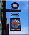
The Castle (2) - sign, 108 King Charles Road, Surbiton
The pub has two signs, one on the frontage to Britannia Road and this one, which is on the frontage to King Charles Road. This is the more interesting because it has a further sign above the picture of a castle. From a distance the sign above looks like a clock but in fact it is a brewery sign. Around the edge it says: "Watney Combe Reid 1898". Watney Combe & Reid were an amalgamation of three brewers formed in 1898, and they based their brewing operations at Watney's Stag Brewery at Victoria, London. This explains why in the middle of the sign there is a picture of a stag which is very faded but can be seen when the photograph is enlarged. The firm became London's largest brewer for many years but the brewery closed in 1958 when they transferred brewing to the brewery of a company they had taken over and changed their name to Watney Mann. Watney Combe & Reid were particularly well-known for brewing Watney's Brown Ale and Hammerton Oatmeal Stout. An interesting historical relict, of which there are probably very few left, particularly as Watneys ceased to exist in 1979.
Image
Image: © P L Chadwick
Taken: 18 Aug 2013
0.14 miles


