IMAGES TAKEN NEAR TO
Pine Gardens, SURBITON, KT5 8LH
Introduction
This page details the photographs taken nearby to Pine Gardens, KT5 8LH by members of the Geograph project.
The Geograph project started in 2005 with the aim of publishing, organising and preserving representative images for every square kilometre of Great Britain, Ireland and the Isle of Man.

There are currently over 7.5m images from over14,400 individuals and you can help contribute to the project by visiting https://www.geograph.org.uk
Image Map
Images are licensed for reuse under creativecommons.org/licenses/by-sa/2.0
Notes
- Clicking on the map will re-center to the selected point.
- The higher the marker number, the further away the image location is from the centre of the postcode.
Image Listing (18 Images Found)
Images are licensed for reuse under creativecommons.org/licenses/by-sa/2.0
Image
Details
Distance
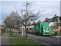
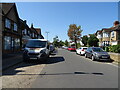
2
Manor Crescent, Berrylands
Classic suburbia.
Image: © Hugh Venables
Taken: 30 Jan 2015
0.10 miles
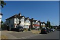
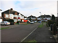
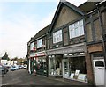
7
Shops on Alexandra Drive, Berrylands
Part of the triangle shops.
Image: © Hugh Venables
Taken: 30 Jan 2015
0.18 miles
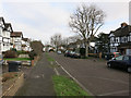
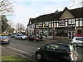
8
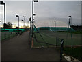
Surbiton Racket and Fitness Club
Surbiton tennis club, in Berrylands.
Image: © Hugh Venables
Taken: 30 Dec 2015
0.19 miles
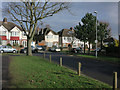
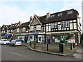
9
Post Office, Berrylands
On Alexandra triangle.
Image: © Hugh Venables
Taken: 30 Jan 2015
0.19 miles