IMAGES TAKEN NEAR TO
Rose Walk, SURBITON, KT5 8HS
Introduction
This page details the photographs taken nearby to Rose Walk, KT5 8HS by members of the Geograph project.
The Geograph project started in 2005 with the aim of publishing, organising and preserving representative images for every square kilometre of Great Britain, Ireland and the Isle of Man.

There are currently over 7.5m images from over14,400 individuals and you can help contribute to the project by visiting https://www.geograph.org.uk
Image Map
Images are licensed for reuse under creativecommons.org/licenses/by-sa/2.0
Notes
- Clicking on the map will re-center to the selected point.
- The higher the marker number, the further away the image location is from the centre of the postcode.
Image Listing (111 Images Found)
Images are licensed for reuse under creativecommons.org/licenses/by-sa/2.0
Image
Details
Distance
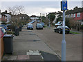
5
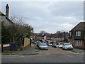
Rose Walk, Berrylands
Rose Walk is a residential cul-de-sac in Berrylands, in the outer suburbs of south west London.
Image: © Malc McDonald
Taken: 17 Feb 2019
0.07 miles
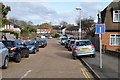
6
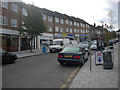
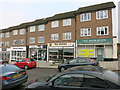
Berrylands shops
Small row of shops and offices on Chilterns Drive close to Berrylands Station.
Image: © Hugh Venables
Taken: 18 Oct 2008
0.07 miles
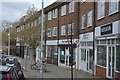
7
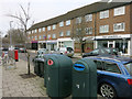
Shops and offices, Chiltern Drive
Close to Berrylands Station.
Image: © Hugh Venables
Taken: 30 Jan 2015
0.07 miles
8
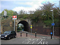
Railway bridge
At the end of Lower Marsh Lane, a cycle route to Surbiton and Kingston.
Image: © Hugh Venables
Taken: 18 Oct 2008
0.07 miles
9
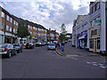
Shops on Chiltern Drive
Close to Berrylands Station.
Image: © Hugh Venables
Taken: 30 Jan 2015
0.07 miles
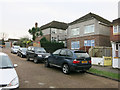
10
Shops on Chiltern Drive, Berrylands
The station is behind me on the cul de sac.
Image: © David Howard
Taken: 12 Aug 2007
0.07 miles