IMAGES TAKEN NEAR TO
Warwick Grove, KT5 8FF
Introduction
This page details the photographs taken nearby to Warwick Grove, KT5 8FF by members of the Geograph project.
The Geograph project started in 2005 with the aim of publishing, organising and preserving representative images for every square kilometre of Great Britain, Ireland and the Isle of Man.

There are currently over 7.5m images from over14,400 individuals and you can help contribute to the project by visiting https://www.geograph.org.uk
Image Map
Images are licensed for reuse under creativecommons.org/licenses/by-sa/2.0
Notes
- Clicking on the map will re-center to the selected point.
- The higher the marker number, the further away the image location is from the centre of the postcode.
Image Listing (52 Images Found)
Images are licensed for reuse under creativecommons.org/licenses/by-sa/2.0
Image
Details
Distance
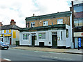
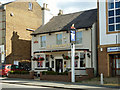
1
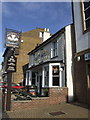
The New Prince, Surbiton
Another of Surbiton's traditional 'local boozers'. A Gales Brewery pub with a good range of their beers. The Fuller's sandwich board shows evidence of the new owners with a hint that you should enjoy Gales beers whilst you can.
Image: © al partington
Taken: 31 Jan 2007
0.05 miles
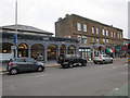
3
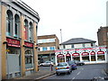
Oak Hill Crescent
Shops at the southern corner with Ewell Road. The French Bistro used to be Bell's shop selling musical instruments. Abbey Beds & Furniture on Ewell Road has an extended frontage around the old house - a common feature along this road.
Image: © Colin Smith
Taken: 12 Dec 2008
0.08 miles
4
Ewell Road
With Image now a Sainsbury's Local.
Image: © Hugh Venables
Taken: 30 Dec 2015
0.08 miles
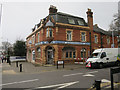
5
The Victoria
On Ewell Road, Surbiton.
Image: © Robin Webster
Taken: 26 Aug 2012
0.08 miles
7
Kings Business Equipment
Now somewhat run down.
Image: © Hugh Venables
Taken: 30 Dec 2015
0.10 miles
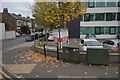
8
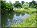
Fishponds Park
Fishponds Park contains three ponds, a stream and an area of grassland now managed as a hay meadow. On a map of 1762 this site is shown as a brick kiln and was part of Kingston Common, which stretched between Hook, Tolworth and Surbiton. By 1839 most of the land had been taken over as allotments, although a brickworks is still shown on the 1867 Ordnance Survey Map. Fishponds itself is a plain Georgian house built in 1742.
This is one of the smaller ponds.
Image: © Marathon
Taken: 10 Jul 2013
0.10 miles
9
The New Prince
On Ewell Road, Surbiton.
Image: © Robin Webster
Taken: 26 Aug 2012
0.10 miles
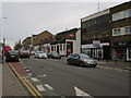
10
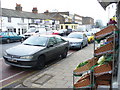
Ewell Road - Shopping on Surbiton Hill
Local shops line both sides of this main road between Kingston and Tolworth. Parking spaces are at a premium.
Image: © Colin Smith
Taken: 12 Dec 2008
0.11 miles