IMAGES TAKEN NEAR TO
Surbiton Hill Park, SURBITON, KT5 8EH
Introduction
This page details the photographs taken nearby to Surbiton Hill Park, KT5 8EH by members of the Geograph project.
The Geograph project started in 2005 with the aim of publishing, organising and preserving representative images for every square kilometre of Great Britain, Ireland and the Isle of Man.

There are currently over 7.5m images from over14,400 individuals and you can help contribute to the project by visiting https://www.geograph.org.uk
Image Map
Images are licensed for reuse under creativecommons.org/licenses/by-sa/2.0
Notes
- Clicking on the map will re-center to the selected point.
- The higher the marker number, the further away the image location is from the centre of the postcode.
Image Listing (14 Images Found)
Images are licensed for reuse under creativecommons.org/licenses/by-sa/2.0
Image
Details
Distance
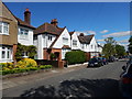
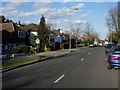
1
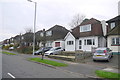
Houses on Surbiton Hill Park
These mock half timbered detached houses probably dating from the 1930's on Surbiton Hill Park are on the south side just east of the junction with The Ridings.
Image: © Nigel Mykura
Taken: 3 Dec 2015
0.03 miles
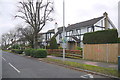
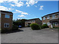
2
Surbiton Hill Park, Berrylands
1930s housing, largely built in response to the railway arriving in 1933.
Image: © Hugh Venables
Taken: 4 Nov 2010
0.04 miles
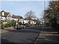
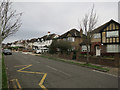
4
Berrylands
Classic suburbia. Road is Surbiton Hill Park.
Image: © Hugh Venables
Taken: 8 Apr 2006
0.17 miles
6
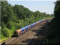
Railway between Surbiton and Berrylands
Image: © Oast House Archive
Taken: 7 Aug 2018
0.19 miles
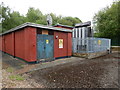
7
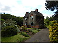
Surbiton - Lower March Lane
Near Clay Hill and Sewage Works.
Image: © James Emmans
Taken: 24 May 2016
0.19 miles
8
Houses on Surbiton Hill Park (2)
These detached houses with mansard roofs are on the south side of the street between the junctions with The Ridings and The Royston.
Image: © Nigel Mykura
Taken: 3 Dec 2015
0.19 miles
9
Berrylands, Berrylands
The road and the area being Berrylands.
Image: © Hugh Venables
Taken: 30 Dec 2015
0.21 miles