IMAGES TAKEN NEAR TO
Merrilands Road, WORCESTER PARK, KT4 8NU
Introduction
This page details the photographs taken nearby to Merrilands Road, KT4 8NU by members of the Geograph project.
The Geograph project started in 2005 with the aim of publishing, organising and preserving representative images for every square kilometre of Great Britain, Ireland and the Isle of Man.

There are currently over 7.5m images from over14,400 individuals and you can help contribute to the project by visiting https://www.geograph.org.uk
Image Map
Images are licensed for reuse under creativecommons.org/licenses/by-sa/2.0
Notes
- Clicking on the map will re-center to the selected point.
- The higher the marker number, the further away the image location is from the centre of the postcode.
Image Listing (4 Images Found)
Images are licensed for reuse under creativecommons.org/licenses/by-sa/2.0
Image
Details
Distance
1
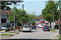
Delcombe Avenue
A typical 1930s suburban street. In the distance are, I think, gas holders at Motspur Park.
Image: © Stephen Richards
Taken: Unknown
0.07 miles
2
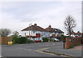
Dorchester Rd
These 1930's semi-detached houses are at the western end of Dorchester Rd close to the junction with Ruskin Drive.
Image: © Nigel Mykura
Taken: 17 Apr 2015
0.13 miles
4
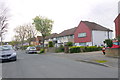
St Philips Avenue.
Looking south along St Philips Ave which consists mainly of small post war terraced houses. This is the northern end of the road close to the junction with Browning Avenue
Image: © Nigel Mykura
Taken: 17 Apr 2015
0.22 miles