IMAGES TAKEN NEAR TO
Motspur Park, NEW MALDEN, KT3 6PT
Introduction
This page details the photographs taken nearby to Motspur Park, KT3 6PT by members of the Geograph project.
The Geograph project started in 2005 with the aim of publishing, organising and preserving representative images for every square kilometre of Great Britain, Ireland and the Isle of Man.

There are currently over 7.5m images from over14,400 individuals and you can help contribute to the project by visiting https://www.geograph.org.uk
Image Map
Images are licensed for reuse under creativecommons.org/licenses/by-sa/2.0
Notes
- Clicking on the map will re-center to the selected point.
- The higher the marker number, the further away the image location is from the centre of the postcode.
Image Listing (13 Images Found)
Images are licensed for reuse under creativecommons.org/licenses/by-sa/2.0
Image
Details
Distance
1
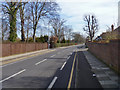
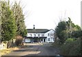
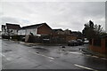
Motspur Park
The Fulham FC training ground is behind the hedge on the left.
Image: © John Allan
Taken: 10 Mar 2015
0.05 miles
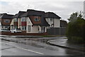
5
Motspur Park: Former BBC Sports Ground Clubhouse
The sports ground become disused and was sold in 2005 to a developer who intended to build a leisure and fitness centre on the site. However local opposition to the proposed scheme was strong, and the latest plans (in October 2007) are suggesting that the sports ground could be turned into a cemetery. This is because planning regulations require the land to remain as a green space and a cemetery is one of the very few options now open to the owners.
This is the clubhouse photographed through the gates to the site off the Motspur Park road.
Image: © Nigel Cox
Taken: 30 Jan 2008
0.16 miles
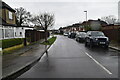
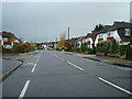
8
Bargate Close, Malden
Suburban commuterland.
Image: © John Allan
Taken: 11 Mar 2015
0.20 miles
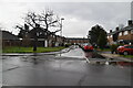
10
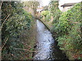
Beverley Brook in West Barnes
Beverley Brook flows out into the River Thames to the east of Barnes. This was taken looking downstream from the Blakes Lane / West Barnes Lane road bridge. The boundary between the London Boroughs of Merton, to the right, and Kingston upon Thames, to the left, runs down the centre of the brook at this location.
Image: © Nigel Cox
Taken: 30 Jan 2008
0.23 miles