IMAGES TAKEN NEAR TO
College Gardens, NEW MALDEN, KT3 6NU
Introduction
This page details the photographs taken nearby to College Gardens, KT3 6NU by members of the Geograph project.
The Geograph project started in 2005 with the aim of publishing, organising and preserving representative images for every square kilometre of Great Britain, Ireland and the Isle of Man.

There are currently over 7.5m images from over14,400 individuals and you can help contribute to the project by visiting https://www.geograph.org.uk
Image Map (Loading...)


Getting Data...Please wait
Leaflet Map data © OpenStreetMap
Images are licensed for reuse under creativecommons.org/licenses/by-sa/2.0
Notes
- Clicking on the map will re-center to the selected point.
- The higher the marker number, the further away the image location is from the centre of the postcode.
Image Listing (12 Images Found)
Images are licensed for reuse under creativecommons.org/licenses/by-sa/2.0
Image
Details
Distance
1
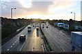
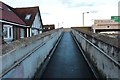
Coombe boys' school on the A3, New Malden
From the footbridge
Image: © David Howard
Taken: 12 Nov 2018
0.06 miles
2
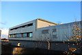
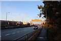
Coombe boys' school on the A3, New Malden
Image: © David Howard
Taken: 12 Nov 2018
0.07 miles
9
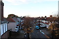
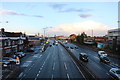
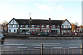
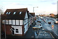
Queen's Road, New Malden
From the A3 footbridge
Image: © David Howard
Taken: 12 Nov 2018
0.12 miles
10
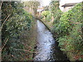
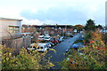
Beverley Brook in West Barnes
Beverley Brook flows out into the River Thames to the east of Barnes. This was taken looking downstream from the Blakes Lane / West Barnes Lane road bridge. The boundary between the London Boroughs of Merton, to the right, and Kingston upon Thames, to the left, runs down the centre of the brook at this location.
Image: © Nigel Cox
Taken: 30 Jan 2008
0.13 miles