IMAGES TAKEN NEAR TO
Blakes Lane, NEW MALDEN, KT3 6NS
Introduction
This page details the photographs taken nearby to Blakes Lane, KT3 6NS by members of the Geograph project.
The Geograph project started in 2005 with the aim of publishing, organising and preserving representative images for every square kilometre of Great Britain, Ireland and the Isle of Man.

There are currently over 7.5m images from over14,400 individuals and you can help contribute to the project by visiting https://www.geograph.org.uk
Image Map
Images are licensed for reuse under creativecommons.org/licenses/by-sa/2.0
Notes
- Clicking on the map will re-center to the selected point.
- The higher the marker number, the further away the image location is from the centre of the postcode.
Image Listing (17 Images Found)
Images are licensed for reuse under creativecommons.org/licenses/by-sa/2.0
Image
Details
Distance
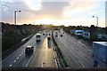
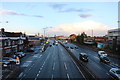
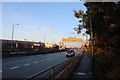
1
Coombe boys' school on the A3, New Malden
From the footbridge
Image: © David Howard
Taken: 12 Nov 2018
0.11 miles
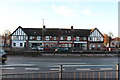
4
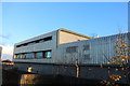
Coombe boys' school on the A3, New Malden
Image: © David Howard
Taken: 12 Nov 2018
0.14 miles
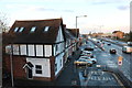
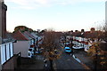
8
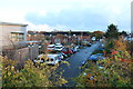
Blakes Lane
1970s maisonettes in Motspur Park.
Image: © Burgess Von Thunen
Taken: 27 Nov 2012
0.15 miles
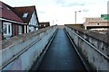
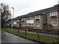
10
Queen's Road, New Malden
From the A3 footbridge
Image: © David Howard
Taken: 12 Nov 2018
0.16 miles