IMAGES TAKEN NEAR TO
Lynton Road, NEW MALDEN, KT3 5ED
Introduction
This page details the photographs taken nearby to Lynton Road, KT3 5ED by members of the Geograph project.
The Geograph project started in 2005 with the aim of publishing, organising and preserving representative images for every square kilometre of Great Britain, Ireland and the Isle of Man.

There are currently over 7.5m images from over14,400 individuals and you can help contribute to the project by visiting https://www.geograph.org.uk
Image Map
Images are licensed for reuse under creativecommons.org/licenses/by-sa/2.0
Notes
- Clicking on the map will re-center to the selected point.
- The higher the marker number, the further away the image location is from the centre of the postcode.
Image Listing (5 Images Found)
Images are licensed for reuse under creativecommons.org/licenses/by-sa/2.0
Image
Details
Distance
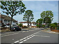
1
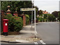
Westbury Road
Residential road in the suburb of New Malden which grew up around its railway station.
http://en.wikipedia.org/wiki/New_Malden
Image: © Colin Smith
Taken: 21 Aug 2012
0.17 miles
2
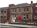
Holy Cross, New Malden
School on Sandal Road, close to New Malden's centre.
Image: © Colin Smith
Taken: 21 Aug 2012
0.20 miles
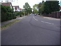
5
New Malden: South Lane
Looking north from the end of Bodley Road
Image: © Dr Neil Clifton
Taken: 16 Jul 2013
0.25 miles