IMAGES TAKEN NEAR TO
Beverley Way, NEW MALDEN, KT3 4PJ
Introduction
This page details the photographs taken nearby to Beverley Way, KT3 4PJ by members of the Geograph project.
The Geograph project started in 2005 with the aim of publishing, organising and preserving representative images for every square kilometre of Great Britain, Ireland and the Isle of Man.

There are currently over 7.5m images from over14,400 individuals and you can help contribute to the project by visiting https://www.geograph.org.uk
Image Map
Images are licensed for reuse under creativecommons.org/licenses/by-sa/2.0
Notes
- Clicking on the map will re-center to the selected point.
- The higher the marker number, the further away the image location is from the centre of the postcode.
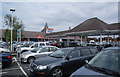
Image Listing (32 Images Found)
Images are licensed for reuse under creativecommons.org/licenses/by-sa/2.0
Image
Details
Distance
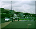
4
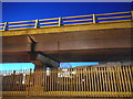
Bushey Road flyover at the A3 junction
The A3 connects in Raynes Park
Image: © David Howard
Taken: 25 Mar 2017
0.10 miles
5
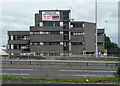
Apex House, Bushey Road
This has caught my eye more than once while flying by on the A3. It has a touch of the Brutalist about it, and appears to be composed of several different-sized interlocking blocks.
As the sign suggests it was empty and available for rent. It comes with a group of sheds (left of shot).
Image: © Stephen Richards
Taken: 13 Aug 2011
0.13 miles
6
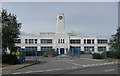
86 Bushey Road
A nice piece of Art Deco with central clock tower. The windows are not original, but the clock might be.
I don't know the dates, but at some point it was used by engine manufacturers Napier, and later cash and carry outfit, Nurdin & Peacock. At the time of the photo I think it was for rent.
Image: © Stephen Richards
Taken: 13 Aug 2011
0.15 miles
7
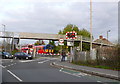
Level Crossing West Barnes Lane
Traffic and pedestrians are waiting at the closed gates as a train goes past over the level crossing where West Barnes Lane meets the Burlington Rd the B282.
Image: © Nigel Mykura
Taken: 30 Oct 2012
0.16 miles
8
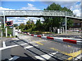
Level crossing at West Barnes Lane
The London & Southampton Railway opened its line from Nine Elms to Southampton in 1838. This soon became the London & South Western Railway. In 1859 the London & South Western Railway opened a branch to Epsom. This left the main line west of Wimbledon. Richard Garth of Morden bought the adjacent West Barnes farmlands from the Rayne family for development and persuaded the LSWR to build a station at the junction. It opened in 1871 and was named Raynes Park, which in turn gave its name to the surrounding district. At this time there was no place of any importance between Wimbledon and Epsom and little traffic used the line except on race days. Although the line had been opened in 1859, a station was not opened until 1925 to serve the West Barnes area, which had been built over during the 1920s and 1930s. This was named Motspur Park. Motspur Park only became a junction in 1938 when the Chessington Branch was opened. This was a very late arrival and never reached through to its planned destination of Leatherhead. The level crossing at West Barnes Lane is half way between Raynes Park and Motspur Park. As it is a fairly busy level crossing, a long footbridge has been built over the line.
Image: © Marathon
Taken: 19 Sep 2012
0.16 miles
9
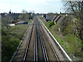
Raynes Park to Epsom line
Looking towards Epsom.
Image: © Robin Webster
Taken: 1 Apr 2012
0.16 miles
10
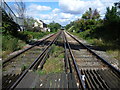
View from level crossing at West Barnes Lane
The London & Southampton Railway opened its line from Nine Elms to Southampton in 1838. This soon became the London & South Western Railway. In 1859 the London & South Western Railway opened a branch to Epsom. This left the main line west of Wimbledon. Richard Garth of Morden bought the adjacent West Barnes farmlands from the Rayne family for development and persuaded the LSWR to build a station at the junction. It opened in 1871 and was named Raynes Park, which in turn gave its name to the surrounding district. At this time there was no place of any importance between Wimbledon and Epsom and little traffic used the line except on race days. Although the line had been opened in 1859, a station was not opened until 1925 to serve the West Barnes area, which had been built over during the 1920s and 1930s. This was named Motspur Park. Motspur Park only became a junction in 1938 when the Chessington Branch was opened. This was a very late arrival and never reached through to its planned destination of Leatherhead. The level crossing at West Barnes Lane is half way between Raynes Park and Motspur Park. This is the view from the crossing towards Raynes Park.
Image: © Marathon
Taken: 19 Sep 2012
0.17 miles