IMAGES TAKEN NEAR TO
High Drive, NEW MALDEN, KT3 3UJ
Introduction
This page details the photographs taken nearby to High Drive, KT3 3UJ by members of the Geograph project.
The Geograph project started in 2005 with the aim of publishing, organising and preserving representative images for every square kilometre of Great Britain, Ireland and the Isle of Man.

There are currently over 7.5m images from over14,400 individuals and you can help contribute to the project by visiting https://www.geograph.org.uk
Image Map
Images are licensed for reuse under creativecommons.org/licenses/by-sa/2.0
Notes
- Clicking on the map will re-center to the selected point.
- The higher the marker number, the further away the image location is from the centre of the postcode.
Image Listing (20 Images Found)
Images are licensed for reuse under creativecommons.org/licenses/by-sa/2.0
Image
Details
Distance
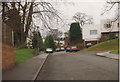
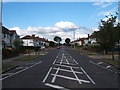
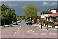
1
High Drive
This is a long quiet residential street consisting mainly of large detached houses . It runs from Coombe Lane West in the north to Clarence Avenue in the south. A four bedroom detached house on this road sold for £990,000 in May 2015.
Image: © Nigel Mykura
Taken: 3 Dec 2015
0.03 miles
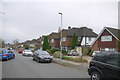
3
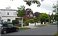
Woodlands Avenue
Amid the more standard brick fare, this road has three more modern houses, one of which can be seen on the left. They are known as 'Sunspan' houses which seen from the air are diamond-shaped, or like a square rotated by 45 degrees, resulting in two facades getting the sun. They were designed by Wells Coates and G. Pleydell Bouverie.
Image: © Stephen Richards
Taken: Unknown
0.12 miles
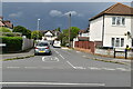
4
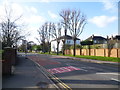
Coombe Lane West looking towards Orchard Rise
This is just up the hill from Norbiton station, and on the edge of the Coombe Estate. This view from near High Drive looks towards the junction with Orchard Rise.
Image: © Marathon
Taken: 30 Jan 2013
0.14 miles
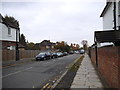
5
Coombe Lane West by Orchard Rise
This is just up the hill from Norbiton station, and on the edge of the Coombe Estate. This view looks along Coombe Lane West (A238) towards Raynes Park. Orchard Rise is to the left.
Image: © Marathon
Taken: 30 Jan 2013
0.14 miles
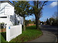
7
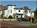
Adventurous architecture in suburbia
Inserted into a sprawl of standard suburban houses is this flat-roofed house on the corner of Clarence Avenue and High Drive.
Image: © Robin Webster
Taken: 1 Apr 2012
0.21 miles